
Hurricane Katrina was the chase that almost killed me several times. Since Hurricane chasing is very dangerous and after Hurricane Dennis, I was out sick for a month because I caught mono from what I think was from the flying debris during the hurricane.
During Hurricane Dennis, which hit the same area as Hurricane Ivan destroyed less than a year before, there was a lot of construction and rebuilding happening. This meant there was a lot of flying debris in the form of destroyed “porta-potties” so one could say that there was a lot of crap in the air.
So I got Mono, which made me deathly ill. That became “Walking Pneumonia” and I was pretty messed up medically speaking by the time Hurricane Katrina came around towards the end of August of 2005. If you watch the footage in the Hurricane Katrina Documentary, you can hear me coughing a lot since I was still very sick.
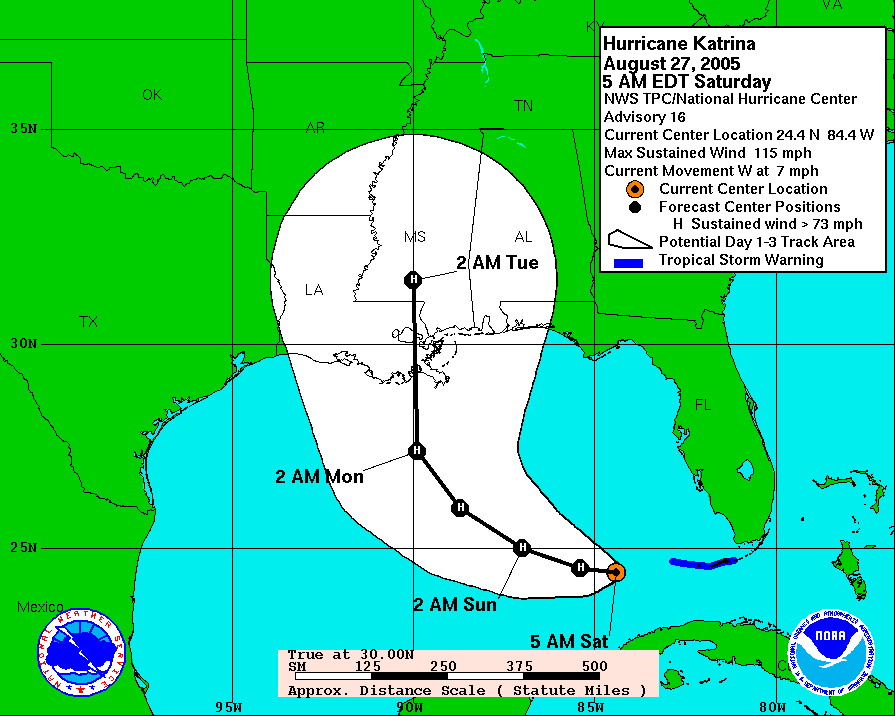
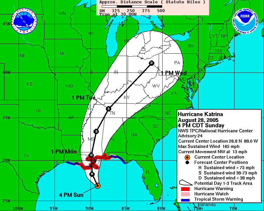
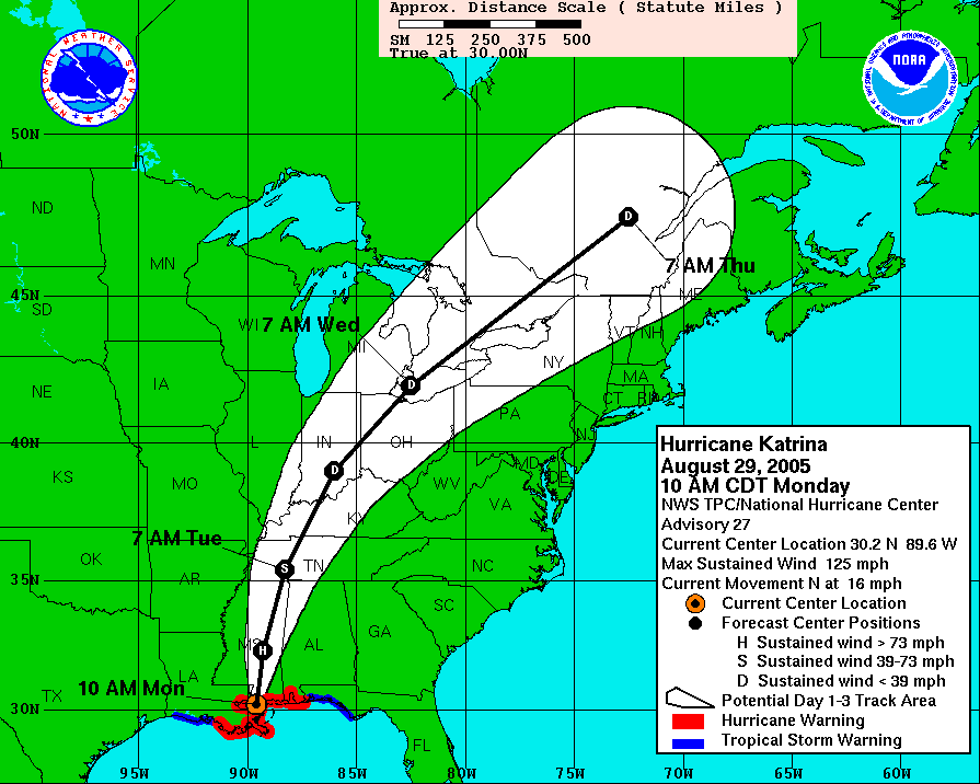
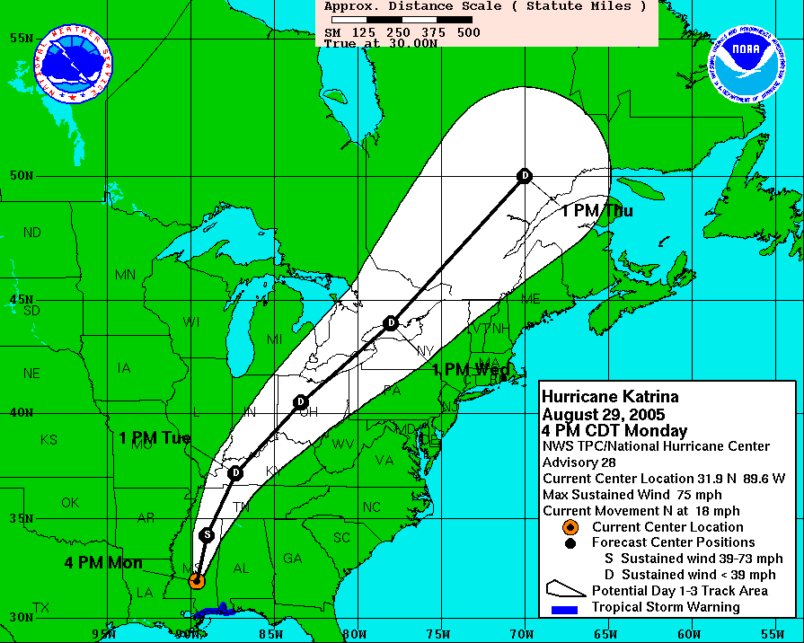
Here is the National Hurricane Center track as of Saturday Morning just before I was leaving home and going to the airport in Minneapolis, MN. I was flying right into the path of the hurricane.
I started out the Katrina intercept in New Orleans, LA with the plan to head east towards Mobile, AL on Thursday August 25th, and hook up with my chase partner Blake. As Friday came and went, it looked as New Orleans was going to be the target after all. So while I was on a lay over in Chicago, IL while flying down to New Orleans, LA, I took one more look at the data and booked up a hotel in the New Orleans, LA area next to the International Airport.
As soon as I hit the ground in New Orleans, well Kenner, LA to be specific and checked into my hotel, I was off to get the last of my survival supplies which included fuel cans and water.
After a few stops to the local stores, I was able to get the last of the supplies I needed that I could not bring on the plane and then it was time to go to work shooting footage.
Here is the first footage I shot after I got setup at my hotel. This is B-Roll footage as the Contraflow from the city of New Orleans, LA begins to expedite the evacuations of the area.
Shots include people waiting for the Contraflow to start, workers setting up orange traffic cones and B-Roll footage of backed up traffic as people try to get out of the city and head west on Interstate 10.
After I was finished shooting some of the B-Roll footage that I have been trying to get for years of a major evacuation, I went back to my hotel to get the footage out and then go scout out the area. I had only been in New Orleans, LA once before and that was just for a few hours as I was passing through after Hurricane Dennis less than two months ago. So I was in a major American city with no clue where anything was but I had my GPS to guide me and tell me how deep under sea level I was.
I headed back out and got dinner at a gas station deli down the street from the hotel and before you say “what were you thinking”, I know I was in NOLA and I ate that junk. Katrina was still forecasted to make landfall just to the south of New Orleans, LA on the 4:00 p.m. NHC forecast and its current max winds were still holding steady at 115 mph.
I spent the better part of the evening scouting out downtown NOLA for locations and escape routes. It was pretty strange when I looked at the GPS on the laptop and I was seeing that my elevation was actually showing up as five feet below sea level in a few locations. I finally made it down to the French Quarter of New Orleans, LA and it was just before midnight and the NHC forecast graphics were still showing Hurricane Katrina to come in just after sunrise on Monday morning and the current winds were still at 115 miles per hour.
I was paying close attention to the latest data from the National Hurricane Center (NHC) which was reporting at the 11:00 p.m. discussion that the winds remained at about 115 MPH but the wind filed was expanding and the winds at the time of the land fall to be about 145 MPH.
I went to the famous Bourbon Street to possibly document the last night on the town, ever! People were in a carefree mood. Nobody seemed to care what was happening or that the hand of god was about to come down on the big easy.
Even with Hurricane Katrina still forecasted to make landfall as a strong category four hurricane, what I saw in Downtown New Orleans, LA was just insane. People were still out partying like nothing was wrong and no storm that could destroy the area was just 36 hours away.
B-Roll footage I shot during the overnight hours in the French Quarter of New Orleans, LA as shop owner’s were boarding up and getting ready for Hurricane Katrina.
At the same time, tourists and locals were partying in the streets into the early morning hours. Footage includes interviews with people on the streets and various B-Roll video of the final night on Bourbon Street before Katrina hit.
When people asked me what I was doing with the video camera, I told them I was filming the last night on the town because it looked as if the town was going to die in 36 hours. Some people thought I was on drugs, while others stopped to tell me their story about being trapped there because the airlines canceled their flights and or shut down operations and they had nowhere else to go.
As Saturday August 27th turned into Sunday August 28th, my hope and prayer was for Katrina to weaken and shift to the east by 100 miles so to spare New Orleans and hit near my first target, Mobile, AL to Pensacola Florida. Not that I have anything against that part of the country but has already seen several major storms within the last year. So the damage has been done to that area and any further damage would not be as bad. You can’t destroy something that is already destroyed.
I made it back to the hotel by 1:45 a.m. and edited the video for the morning shows and went to bed thinking that maybe the hurricane will fall apart like Hurricane Dennis did back in July. I knew I was in for a long day of work the next day so the plan was to sleep in until noon and get a good long rest before intercepting the hurricane by myself the next night and into Monday morning.
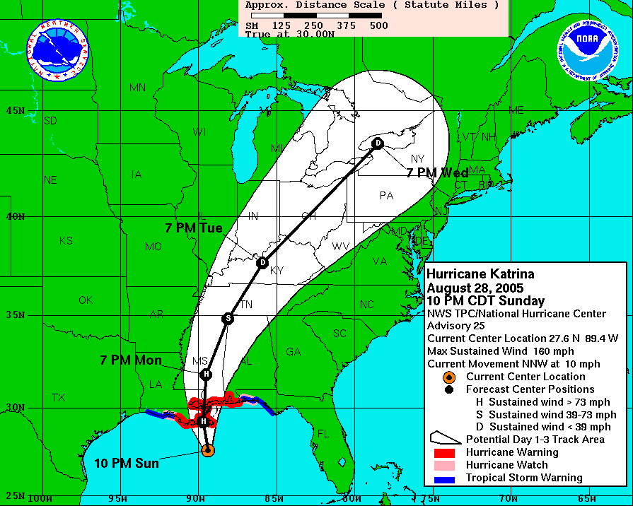
While I slept in on the morning of August 28th, 2005 and rested up for what I thought was going to be a busy chase further to my east, I was wrong. I woke up before noon and saw this forecast from NHC.
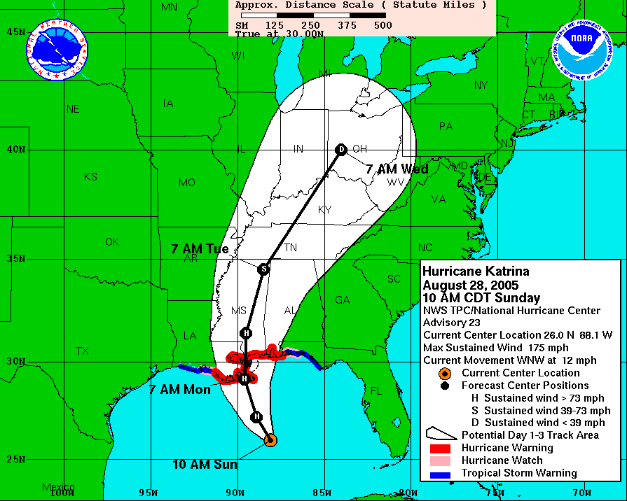
I went to bed early in the morning with the hurricane in the Gulf of Mexico at 115 MPH with a forecasted winds at landfall to be between 140 to 145 MPH on Monday morning.
Looking at the NHC Discussion Number 23
HURRICANE KATRINA DISCUSSION NUMBER  23
NWS TPC/NATIONAL HURRICANE CENTER MIAMI FL
11 AM EDT SUN AUG 28 2005

THE AIR FORCE HURRICANE HUNTERS JUST MEASURED A 166 KT FLIGHT LEVEL
WIND IN THE NORTHEAST EYEWALL...WHICH REQUIRES AN ADDITIONAL UPWARD
ADJUSTMENT OF THE CURRENT INTENSITY TO 150 KT.
My thought was Whoda Jigga What????
Because now the forecast for landfall was
 12HR VT     29/0000Z 27.2N  88.9W   145 KT
 24HR VT     29/1200Z 29.1N  89.6W   140 KT
Which is in laymen’s terms the winds in 12 hours were forecast to be 145 Knots, or just under 167 Miles Per Hour Sustained Winds!!!
The 24 hour forecast showed that the winds were to drop down to 140 Knots, which is just over 161 Miles Per Hour.
Those are not forecasted wind gusts but forecasted sustained winds and a Category Five (hand of god) hurricane is a storm with sustained winds greater than 155 MPH or greater then 135 Knots. A Cat 5 hurricane hitting a major metro area such as New Orleans, LA would lay waste to this area.
How bad of news was this for me being in New Orleans, LA with a Cat 5 hurricane coming here? Um it was so bad that I had several friends and even ex girlfriends call me to tell to get the hell out of there because if I stayed I would probably get killed.
After taking in the forecast data and thinking if I was going to die, I might as well get some of the best damn hurricane footage ever, I got my gear together and went back out to check out the evacuation.
This was when I found out while I was sleeping, the Mayor of New Orleans, LA ordered the first ever mandatory evacuation order for the city.
I shot a lot of B-Roll footage of the mass panic Contraflow evacuation on 08/28/2005.
With the Mayor of New Orleans, LA calling for the first time ever, a mandatory evacuation of the city, the area residents rush to leave the area.
Video of police directing traffic to get on the interstate and cars driving very slow on interstate 10. Footage shot along Interstate 10 at Williams Blvd and Veterans Blvd.
More B-Roll footage of the Contraflow traffic on Interstate 10 at Williams Blvd. on 8/28/2005 as people waited to evacuate the area with less then 24 hours before Hurricane Katrina makes landfall. Video includes aerial shots from a closed off overpass of the massive traffic jam in all lanes of traffic heading towards the west. This footage catalog starts out with the final aerial Pre Katrina skyline shot of the city and then aerial footage of the massive traffic jam moving towards the camera.
Additional footage of National Guard and Police directing traffic into the Contraflow lanes on Interstate 10. Catalog ends with footage of some of the last flights out of the city from the airport and close up shot of the airport terminal and control tower.
By Sunday afternoon, it looked like the worst case scenario and New Orleans, LA was going to take a direct or near direct hit and would be destroyed by Hurricane Katrina.
Winds of 165 Knots and forecast winds at the time of landfall of 145 Knots or over 165 MPH. While the forecast track for Katrina was still showing the eye of the storm to pass over or near the city of New Orleans, LA, other hurricane chasers were going for the worst winds and storm surge just to the east around the Slidell, LA to Bay St. Louis, MS and everyone was avoiding New Orleans, LA because of the possible flooding. I stayed for Hurricane Katrina in NOLA to document the winds and flooding because I knew it would be the main story if the levee system failed.
As the time passed and it was now Sunday evening, I was even starting to ask myself “What The Hell Are You Doing, Your Going To Die!” I knew I had a job to do and this was a once in a lifetime chase to document history in the making. I did take one last trip into downtown to shoot some of the last footage of the French Quarter.
On the way downtown, I spotted something interesting near the airport. There were putting up one last levee across airline highway.
When I saw people still partying in New Orleans, LA in the French Quarter on the evening of August 28th, 2005 I had to say to myself, now I know what the people on the Titanic must have been doing and feeling before their ship sank. The party was still happening as a Cat 5 hurricane was now heading towards the city and the outer rain bands were starting to fall on Bourbon Street.
As the outer rain bands of Hurricane Katrina were starting to pickup in intensity, I went back to the hotel to get the latest video out before heading back out to document the storm for the rest of the night. The current winds of Hurricane Katrina were now 160 MPH as of the 10:00 p.m. forecast from NHC and it looked as if the right front part of the eye of Katrina would miss New Orleans, LA and hit Mississippi.
Here is the B-Roll video I shot of Hurricane Katrina as the storm starts to hit the Lake Pontchartrain Levee in Kenner, LA.
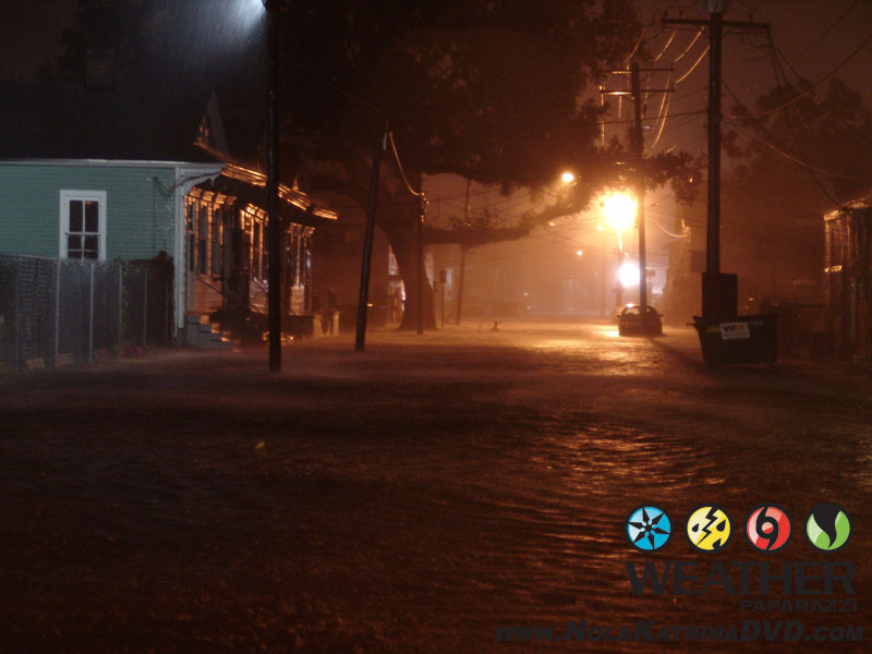
The winds from Katrina start to pick up and the water starts to rise as the hurricane pushes the water to the south side of Lake Pontchartrain and the water starts to rise into a parking lot and over the lake wall.
Footage shots include tree’s blowing in the wind and a stop sign being torn apart by the winds of the hurricane. Video also includes footage of the Kenner, LA police out patrolling in the middle of the storm to secure the area around the Pontchartrain Center.
The forecast was still at Cat5 and it was at this time I was stopped by the police asking what the heck I was doing out in the storm. They asked me to prove I was with the media. I showed them my paperwork and it did check out that I was not just some idiot out in the storm shooting video but a professional videographer covering the storm. The officer told me that I was on my own if ANYTHING happened to me and asked that I write my name and social security number on my arm with a Sharpie Marker to help them I.D. me after they find me dead after the storm. Told him I already had done that and it was on the inside of my right arm. He wished me luck and to try and stay safe and I said thanks with a smile.
Here is the 10:00 p.m. NHC forecast for Katrina and why they were on edge with me running round the streets.
HURRICANE KATRINA ADVISORY NUMBER  25
NWS TPC/NATIONAL HURRICANE CENTER MIAMI FL
10 PM CDT SUN AUG 28 2005

...POTENTIALLY CATASTROPHIC HURRICANE KATRINA CONTINUES TO APPROACH
THE NORTHERN GULF COAST...

A HURRICANE WARNING IS IN EFFECT FOR THE NORTH CENTRAL GULF COAST
FROM MORGAN CITY LOUISIANA EASTWARD TO THE ALABAMA/FLORIDA
BORDER...INCLUDING THE CITY OF NEW ORLEANS AND LAKE PONTCHARTRAIN.
PREPARATIONS TO PROTECT LIFE AND PROPERTY SHOULD BE RUSHED TO
COMPLETION.

AT 10 PM CDT...0300Z...THE CENTER OF HURRICANE KATRINA WAS LOCATED
NEAR LATITUDE 27.6 NORTH...LONGITUDE 89.4 WEST OR ABOUT 105 MILES
SOUTH OF THE MOUTH OF THE MISSISSIPPI RIVER AND ABOUT 170 MILES
SOUTH-SOUTHEAST OF NEW ORLEANS LOUISIANA.

KATRINA IS MOVING TOWARD THE NORTH-NORTHWEST NEAR 10 MPH...AND A
TURN TO THE NORTH IS EXPECTED OVER THE NEXT 12 TO 24 HOURS. ON THE
FORECAST TRACK THE CENTER OF THE HURRICANE WILL BE VERY NEAR THE
NORTHERN GULF COAST MONDAY MORNING.  HOWEVER...CONDITIONS ARE
ALREADY DETERIORATING ALONG PORTIONS OF THE CENTRAL AND
NORTHEASTERN GULF COAST...AND WILL CONTINUE TO WORSEN THROUGH THE
NIGHT.

MAXIMUM SUSTAINED WINDS ARE NEAR 160 MPH WITH HIGHER GUSTS. KATRINA
IS A CATEGORY FIVE HURRICANE ON THE SAFFIR-SIMPSON SCALE. SOME
FLUCTUATIONS IN STRENGTH ARE LIKELY PRIOR TO LANDFALL...AND KATRINA
IS EXPECTED TO MAKE LANDFALL AT EITHER CATEGORY FOUR OR FIVE
INTENSITY.  WINDS AFFECTING THE UPPER FLOORS OF HIGH-RISE BUILDINGS
WILL BE SIGNIFICANTLY STRONGER THAN THOSE NEAR GROUND LEVEL.
Now I had one last chance to edit footage and get the video out before the power was knocked out by the hurricane and everything was suppose to be laid to waste. So I raced backed to the hotel and edited the footage as fast as possible and uploaded it to the station and the network. At the same time I were smelling smoke and so was several other people in the hotel.
Several of us checked around the hotel and could not find anything wrong with the building so we assumed it was from outside.
So not finding anything around the hotel or just outside of the hotel on fire, the heavy smell of smoke was in the air and I knew something had to have been on fire nearby.
This is the B-Roll footage I shot after midnight on 8/29/2005 as a massive fire in Kenner, LA that burned down a building as the winds of Hurricane Katrina’s eye moved closer to New Orleans, LA.
The winds of Hurricane Katrina fanned the fire as fire fighters tried to prevent the flames from spreading to other nearby buildings and homes. Shots include POV dash camera heading towards the fire and shows power lines shorting out and sparking in the high winds.
After I documented the fire, I knew I did not have anymore time to edit and upload footage on the fly since it was now game on for the hurricane chase.
It was after 3:00 a.m. in the morning and it was do or die, put up or shut up, game on. Everything that I have worked for over the last several years was now on the line.
Hurricane Katrina was about to come on shore and it was still a Category Five Hurricane per the 2:00 a.m. NHC Update.
HURRICANE KATRINA INTERMEDIATE ADVISORY NUMBER  25B
NWS TPC/NATIONAL HURRICANE CENTER MIAMI FL
2 AM CDT MON AUG 29 2005

...POTENTIALLY CATASTROPHIC HURRICANE KATRINA BEGINNING TO TURN
   NORTHWARD TOWARD SOUTHEASTERN LOUISIANA AND THE NORTHERN GULF
   COAST...
...SUSTAINED HURRICANE-FORCE WINDS OCCURRING ALONG THE
   SOUTHEASTERN LOUISIANA COAST.
...AT 2 AM CDT...0700Z...THE CENTER OF HURRICANE KATRINA WAS
LOCATED NEAR LATITUDE 28.2 NORTH...LONGITUDE 89.6 WEST OR ABOUT
70 MILES SOUTH-SOUTHWEST OF THE MOUTH OF THE MISSISSIPPI RIVER
AND ABOUT 130 MILES SOUTH-SOUTHEAST OF NEW ORLEANS LOUISIANA.

KATRINA IS NOW MOVING TOWARD THE NORTH NEAR 12 MPH. THIS MOTION IS
FORECAST TO CONTINUE TODAY WITH A GRADUAL INCREASE IN FORWARD
SPEED.  A TURN TOWARD THE NORTH-NORTHEAST IS EXPECTED LATER TONIGHT AND ON TUESDAY. ON THE FORECAST TRACK THE CENTER OF THE HURRICANE WILL BE VERY NEAR THE NORTHERN GULF COAST LATER THIS MORNING. HOWEVER... CONDITIONS ARE GRADUALLY DETERIORATING ALONG PORTIONS OF THE CENTRAL AND NORTHEASTERN GULF COAST...AND WILL CONTINUE TO WORSEN THROUGHOUT THE DAY.

MAXIMUM SUSTAINED WINDS ARE NEAR 155 MPH WITH HIGHER GUSTS.
KATRINA IS NOW A STRONG CATEGORY FOUR HURRICANE ON THE
SAFFIR-SIMPSON SCALE. SOME FLUCTUATIONS IN STRENGTH ARE LIKELY
PRIOR TO LANDFALL...BUT KATRINA IS EXPECTED TO MAKE LANDFALL AS
EITHER A CATEGORY FOUR OR POSSIBLY A CATEGORY FIVE HURRICANE.
WINDS AFFECTING THE UPPER FLOORS OF HIGH-RISE BUILDINGS WILL BE
SIGNIFICANTLY STRONGER THAN THOSE NEAR GROUND LEVEL.
Now at this point all the fear that I had running through my mind about how bad this hurricane was going to be was pretty real. I was still able to run back to my hotel and pack up all my stuff and drive west as fast as I could to get out of the path of Katrina. Instead, I knew that this was a once in a life time chance to document a hurricane hitting a major metro area and their was nobody else around. No viewer video and for the most part, not even very many if any news crews out on the street.
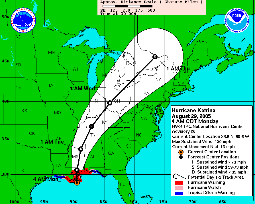
When I got up to the intersection of Interstate 10 and Williams Blvd., it was my last chance to back out of the chase and get out of the area and head off to the west. Instead, I waited on the overpass for a few minutes until the 4:00 a.m. NHC hurricane forecast.
HURRICANE KATRINA ADVISORY NUMBER  26
NWS TPC/NATIONAL HURRICANE CENTER MIAMI FL
4 AM CDT MON AUG 29 2005
AT 4 AM CDT...0900Z...THE CENTER OF HURRICANE KATRINA WAS LOCATED
NEAR LATITUDE 28.8 NORTH... LONGITUDE 89.6 WEST OR ABOUT 90 MILES
SOUTH-SOUTHEAST OF NEW ORLEANS LOUISIANA AND ABOUT 120 MILES
SOUTH-SOUTHWEST OF BILOXI MISSISSIPPI.

KATRINA IS MOVING TOWARD THE NORTH NEAR 15 MPH... AND THIS
MOTION IS FORECAST TO CONTINUE TODAY. A GRADUAL TURN TOWARD THE
NORTH-NORTHEAST AT A SLIGHTLY FASTER FORWARD SPEED IS EXPECTED
LATER TONIGHT AND ON TUESDAY. ON THE FORECAST TRACK...KATRINA WILL
MOVE ONSHORE THE SOUTHEASTERN LOUISIANA COAST JUST EAST OF GRAND
ISLE THIS MORNING... AND REACH THE LOUISIANA-MISSISSIPPI BORDER
AREA THIS AFTERNOON. CONDITIONS WILL CONTINUE TO STEADILY
DETERIORATE OVER CENTRAL AND SOUTHEASTERN LOUISIANA...SOUTHERN
MISSISSIPPI...AND SOUTHERN ALABAMA THROUGHOUT THE DAY.

MAXIMUM SUSTAINED WINDS ARE NEAR 150 MPH...240 KM/HR...WITH HIGHER
GUSTS. KATRINA IS A STRONG CATEGORY FOUR HURRICANE ON THE
SAFFIR-SIMPSON SCALE. SOME FLUCTUATIONS IN STRENGTH ARE LIKELY
PRIOR TO LANDFALL...BUT KATRINA IS EXPECTED TO MAKE LANDFALL AS
A CATEGORY FOUR HURRICANE. WINDS AFFECTING THE UPPER FLOORS OF
HIGH-RISE BUILDINGS WILL BE SIGNIFICANTLY STRONGER THAN THOSE NEAR
GROUND LEVEL.
Katrina was now down to a Category Four hurricane with winds of 150 miles per hour and it looked as if the storm was going to decrease in strength more prior to landfall. From the looks of the forecast, I was going to be on the west side of the hurricane eye wall which meant that the max winds minus the forward motion would bring winds of 135 miles per hour in downtown NOLA. With all the other hurricane chasers that I knew of chasing this storm, they were all to my east to get into position for the max winds on the right front of the eye. I was the only Hurricane Chaser roaming the streets of New Orleans metro and it was time to head into downtown to intercept the eye of the storm.
It was time to head into Downtown New Orleans, LA. Here is the raw B-Roll footage of Hurricane Katrina I shot during the early morning hours while going from Kenner, LA to downtown New Orleans, LA.
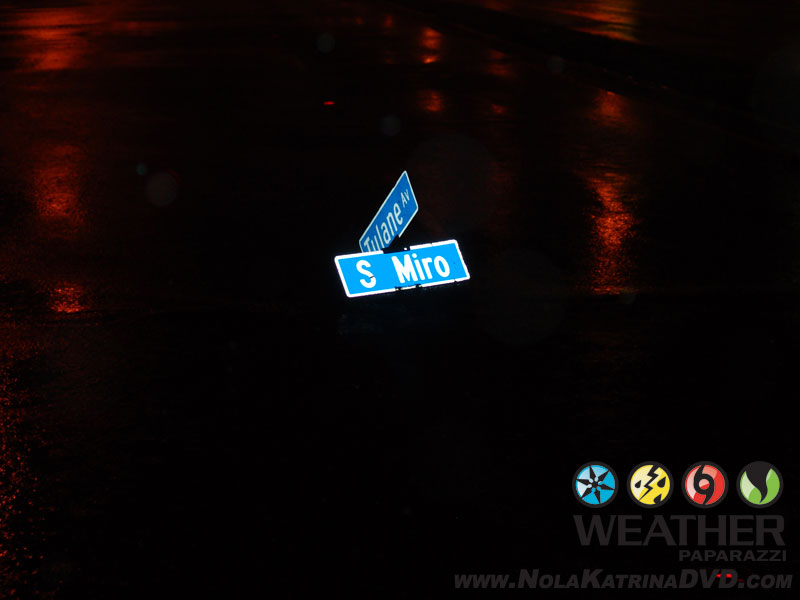
This is footage while driving from the area in Kenner, LA and where I stop to check out the forecast is the 3:20 time frame of the footage. The video after that scene is POV footage while driving on Interstate 10 as I drove into the city and got shots along Tulane Avenue at South Lopez as the heavy rain starts to flood the residential area.
At this point, I drove down Tulane Avenue and into downtown New Orleans, LA as Hurricane Katrina’s winds were becoming stronger by the minute as the eye of the storm moved closer and closer to the city.
After I got into downtown, I got out of the truck and shot footage outside in the hurricane force winds at the intersection of O’Keefe Avenue and University Place.
The winds are pretty strong at this point as they pick up and scream through the buildings in downtown New Orleans, LA.
I changed locations More raw B-Roll footage of crazy high winds of Hurricane Katrina shot during the pre dawn hours in New Orleans, LA.
Video of POV shots and tripoded shots in downtown New Orleans, LA around the French Quarter, Canal Street and includes footage of the police still out on patrol during the hurricane.
Last part of the video catalog includes footage of hurricane force winds on Carondelet Street at the intersection of Common Street. This footage shows large heavy debris being picked up and blown down the street.
Still in the early morning hours of August 29th, this is raw B-Roll footage while the power was still on in the pre dawn hours. The video starts out with POV footage on Canal Street in the middle of Hurricane Katrina while driving around downtown New Orleans, LA.
The video then continues with tripoded footage on Canal Street at Rampart Street of debris flying around and falling on the streets.
Footage of a police squad car driving on Canal Street in the middle of the storm through the debris and video of a billboard being ripped apart by the wind.
Here are some images of the storm damage on Canal Street in NOLA during the winds of Hurricane Katrina in the pre-dawn hours.
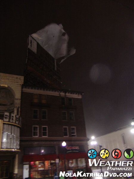
Billboard blown apart during the winds of Hurricane Katrina in downtown New Orleans, LA 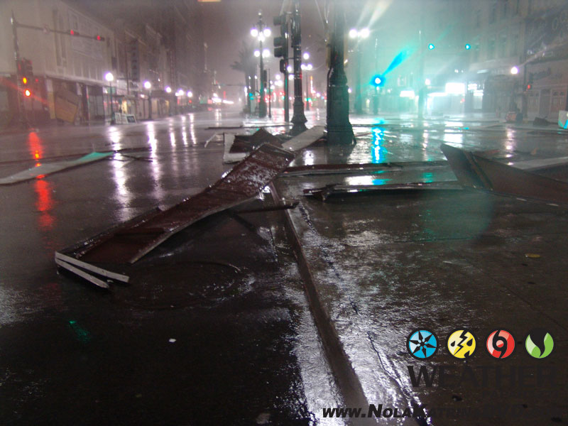
Billboard blown apart during the winds of Hurricane Katrina in downtown New Orleans, LA 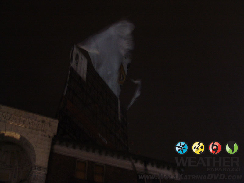
Billboard blown apart during the winds of Hurricane Katrina in downtown New Orleans, LA 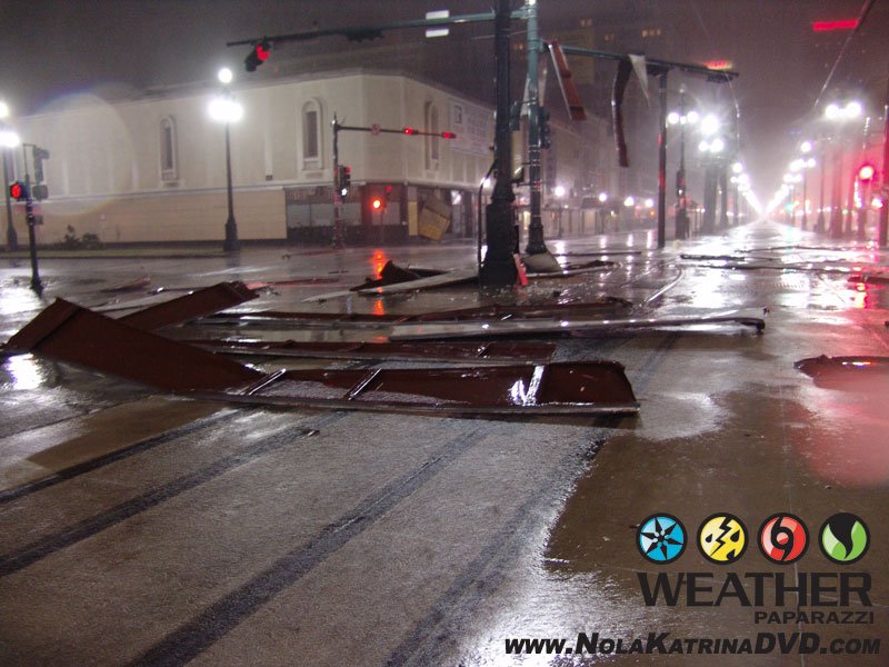
Billboard blown apart during the winds of Hurricane Katrina in downtown New Orleans, LA
I continued to drive around in downtown New Orleans during Hurricane Katrina and shot a lot of B-Roll POV footage during the pre dawn hours as the eye of Hurricane Katrina moved closer to the city.
In this video I was driving around the area of the Superdome. It shows the area around the Superdome was already starting to flood from the heavy rain around just after 6:00 a.m.
The footage continues as the winds grow stronger and then at the intersection of Poydras Street and South Rampart Street when the it shows the power failing and the street lights go dim. The time was 6:21 a.m. when the lights went out as the city was feeling the wrath of Katrinas western eyewall.
The power had just failed and I was driving around in the debris field of Hurricane Katrina as the winds were picking up and blowing the rocks off the top of the buildings in downtown New Orleans, LA. Tree’s were falling and debris was flying as the sun was rising on the final day of Pre Katrina, New Orleans.
The lastest forecast from the National Hurricane Center:
HURRICANE KATRINA INTERMEDIATE ADVISORY NUMBER  26A...CORRECTED
NWS TPC/NATIONAL HURRICANE CENTER MIAMI FL 6 AM CDT MON AUG 29 2005
AT 6 AM CDT...1100Z...THE CENTER OF MAJOR HURRICANE KATRINA WAS
LOCATED NEAR LATITUDE 29.1 NORTH... LONGITUDE 89.6 WEST OR ABOUT
MIDWAY BETWEEN GRAND ISLE AND THE MOUTH OF THE MISSISSIPPI RIVER.
THIS IS ALSO ABOUT 70 MILES SOUTH-SOUTHEAST OF NEW ORLEANS
LOUISIANA AND ABOUT 95 MILES SOUTH-SOUTHWEST OF BILOXI MISSISSIPPI.

KATRINA IS MOVING TOWARD THE NORTH NEAR 15 MPH... AND THIS
MOTION IS FORECAST TO CONTINUE TODAY. A GRADUAL TURN TOWARD THE
NORTH-NORTHEAST AT A SLIGHTLY FASTER FORWARD SPEED IS EXPECTED
LATER TONIGHT AND ON TUESDAY. ON THE FORECAST TRACK...KATRINA WILL
MOVE ONSHORE THE SOUTHERN COAST OF PLAQUEMINES PARISH NEAR EMPIRE
AND BURAS LOUSIANA WITHIN THE ENXT HOUR...AND REACH THE
LOUISIANA-MISSISSIPPI BORDER AREA BY EARLY AFTERNOON. CONDITIONS
WILL CONTINUE TO STEADILY DETERIORATE OVER CENTRAL AND SOUTHEASTERN LOUISIANA...SOUTHERN MISSISSIPPI...AND SOUTHERN ALABAMA THROUGHOUT THE DAY.

MAXIMUM SUSTAINED WINDS ARE NEAR 145 MPH...WITH HIGHER
GUSTS. KATRINA IS A STRONG CATEGORY FOUR HURRICANE ON THE
SAFFIR-SIMPSON SCALE. SOME FLUCTUATIONS IN STRENGTH ARE LIKELY
PRIOR TO LANDFALL...BUT KATRINA IS EXPECTED TO MAKE LANDFALL AS
A CATEGORY FOUR HURRICANE. WINDS AFFECTING THE UPPER FLOORS OF
HIGH-RISE BUILDINGS WILL BE SIGNIFICANTLY STRONGER THAN THOSE NEAR
GROUND LEVEL.

KATRINA REMAINS A VERY LARGE HURRICANE. HURRICANE FORCE WINDS EXTEND OUTWARD UP TO 120 MILES FROM THE CENTER...AND TROPICAL STORM FORCE WINDS EXTEND OUTWARD UP TO 230 MILES.  DURING THE PAST HOUR...A SUSTAINED WIND OF 56 MPH WITH A GUST TO 85 MPH WAS REPORTED AT NEW ORLEANS LAKEFRONT AIRPORT...AND A SUSTAINED WIND OF 74 MPH WITH A GUST TO 96 MPH WAS REPORTED AT THE NAVAL AIR STATION IN BELLE CHASSE LOUISIANA.
This video is POV B-Roll of Hurricane Katrina at 6:25 a.m. as I was driving through the dim lit streets of New Orleans, LA. Katrina’s western eye wall was moving closer to the downtown area and the winds were becoming more intense by the minute.
I shot this footage from Poydras and South Rampart to Canal Street as debris was flying through the air and trees are falling down and blocking the roadway.
There was one lone NOPD squad car on patrol checking out what Katrina’s winds were doing to the city. The squad car soon left the area as the winds grew stronger. The video ends just before 6:38 a.m..
I was shooting with two cameras during Hurricane Katrina and as the POV footage ends in the last video, the coverage continues on the other camera that I was using to shoot out the side window.
Debris was flying past the camera and me at 6:38 a.m. before I moved back to Canal Street.
The bulk of the footage in this video is Hurricane Katrina on Canal Street at the intersection of North Peter Street.
The footage shows hurricane force winds from Katrina slamming into the downtown area across the street from Harrah’s Casino and Hotel on Canal Street.
Raw footage with lots of high winds and debris flying through the air as the hurricane winds rip apart the city. The video ends at 7:00 a.m..
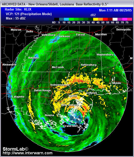
The time now was 7:11 in the morning and the western edge of the eye of Hurricane Katrina was now less than 15 miles away from downtown, New Orleans.
I kept shooting footage as I got back into my truck and documented Hurricane Katrina on Canal Street.
I shot POV footage driving on Canal Street in the middle of Hurricane Katrina with high winds and debris flying through the air as palm trees on Canal Street were knocked over and blocking the road.
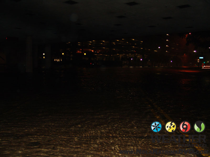
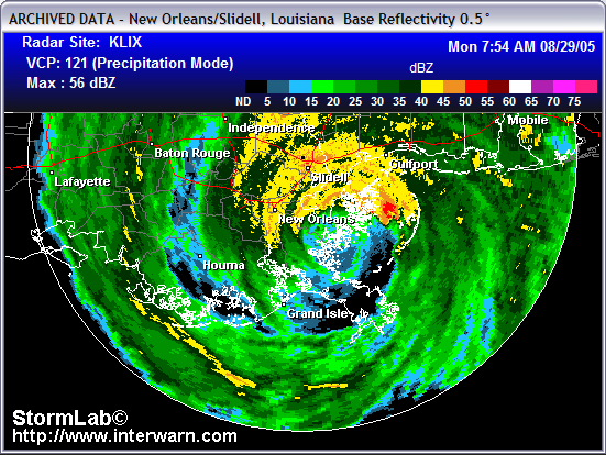
At the same time as the radar image above, 7:11 a.m. I pulled into the parking lot of the Marriott hotel on Canal Street. I setup my second video camera outside while I let the dash camera keep rolling inside the parking garage. There was several Police and EMS personnel also standing here watching the city being devastated by the hurricane.
This was when I saw something insane and got video of a man holding onto a light pole in the high winds on Canal Street. I kept shooting from this location and got footage roofs being torn off buildings. The video above ends at 7:32 a.m. and continues in the next video at 7:34 a.m..
While still outside of the hotel on Canal Street and the western eye wall of Katrina moving closer to the area, the winds were becoming extreme as they blew through the tall buildings.
While part of me was screaming to head to the east to intercept the eye of the hurricane, I knew the real story was here in NOLA. The area to my east in the was the lower 9th ward and Arabi, LA which looking back it was a good idea that I stayed in downtown.
I stayed at this location for a while and it was 7:51 a.m. when I finally left to continue to roam the city streets in the French Quarter as the eye of Katrina was just a few miles to the east of me.
I still felt pretty safe since there was still that one lone police car running around downtown and I did not see anyone else out on the streets except for the man that was hanging onto to the sign.
The time now was 7:54 a.m. as I got back in the truck and started to roam the city streets in the middle of the hurricane. The radar showed that the eye would miss the city. The western edge of the eye of Hurricane Katrina was only about 10 miles away from downtown at this time and the winds were really picking up speed now.
The latest forecast from NHC said:
HURRICANE KATRINA INTERMEDIATE ADVISORY NUMBER  26B
NWS TPC/NATIONAL HURRICANE CENTER MIAMI FL
8 AM CDT MON AUG 29 2005
AT 8 AM CDT...1300Z...THE CENTER OF HURRICANE KATRINA WAS LOCATED
NEAR LATITUDE 29.7 NORTH... LONGITUDE 89.6 WEST OR ABOUT 40 MILES
SOUTHEAST OF NEW ORLEANS LOUISIANA AND ABOUT 65 MILES SOUTHWEST OF
BILOXI MISSISSIPPI... ...KATRINA IS MOVING TOWARD THE NORTH NEAR 15 MPH...
...MAXIMUM SUSTAINED WINDS ARE NEAR 135 MPH...WITH HIGHER GUSTS.
KATRINA IS AN EXTREMELY DANGEROUS CATEGORY FOUR HURRICANE ON THE
SAFFIR-SIMPSON SCALE...
Since I was on the western side of the eye of Katrina, I figured I was now going to see Category Three winds after I subtract the forward motion of the storm for the max winds.
With that being said, max sustained winds on the west side of 120 but more like in the 115 MPH range a few miles away from the eye wall in the major downtown area was nothing to joke about.
I continued to shoot B-Roll footage shot during Hurricane Katrina in the French Quarter. This is a mix of POV footage while driving in the French Quarter as the hurricane rips apart the area.
I did make sure I got out and got additional tripoded video at the intersection of Dauphine Street and Conti Street.
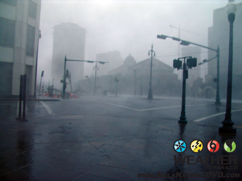
POV footage continues around the French Quarter until the intersection of Conti Street and Royal Street where whiteout condition from the high winds were slamming into the area and blowing debris through the air. The video ends at 8:18 a.m.
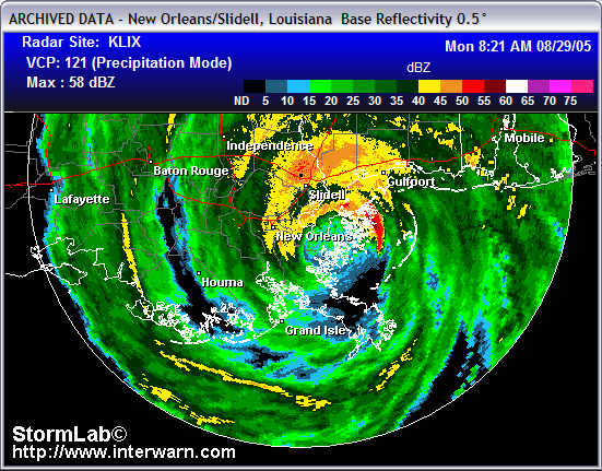
I got back into the truck to keep moving and keep looking for the worst of the winds in the downtown area. It was 8:20 in the morning and the latest radar image showed that the eye wall was just under 10 miles away from where I was.
I had missed the eye of the storm and the max winds of Hurricane Katrina on the right front of the eye wall. The unofficial max winds near me were being reported in the 120 mph range about five miles east of me. Those wind speeds really did not mean much to me because the winds I was in were being impacted by the tall buildings of downtown.
As you can see in this footage shot on Canal Street in New Orleans, LA as the eye wall of Hurricane Katrina slams into the area at the height of the high winds.
The POV footage and main camera catch large debris being tossed into the air. The video shows extreme high winds causing whiteout conditions on Canal Street as the city was being ripped apart by Hurricane Katrina.
The time now was 8:26 a.m. as I moved locations again to keep looking for various shots of flying debris and stuff being ripped apart by the winds. The winds funneling through the city streets and bouncing off the tall buildings was making it hit or miss with the wind gusts.
It was at this point where an man whose name I never got, came up to me in the middle of the Canal Street to tell me the levee’s failed.
As the worst of the hurricane hit east of the city in the Mississippi region, the worst of the destruction was just starting to happen in New Orleans, LA as the levees failed.
This unknown man comes up to me and tells me that he just had to get out of his house and the water was up to the second floor. He wanted to get in and ride with me but I had the laptop and camera gear sitting in the front seat with my camera tripods and survival gear taking up the back of the truck.
The POV footage continues while I called into The Weather Channel and talked to Eileen to tell her what I just heard but could not be confirmed.
I made it up to St. Bernard Avenue and North Claiborne Avenue at Interstate 10. The water was rising fast as the city begins to flood from the failed levee system. The video ends at 8:48 a.m. and I start to make my escape from New Orleans.
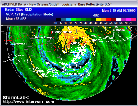
This was it, the radar showed this was as close to the eye of Hurricane Katrina that I would get and then the storm would move off to the northeast within a couple of hours. I missed the eye of the storm but I got the flooding and the extreme winds in downtown. The eye, or what was left of the eye of Katrina was only about eight miles to my east now but it was time to go.
The time was 8:53 a.m. and I was being blasted by high winds and flying debris as I made the decision to leave downtown and head back to the west. The peak winds at my location were happening now but with the levee failure or maybe several failures taking place, I had to leave.
The video starts at St. Bernard Avenue and North Claiborne Avenue to Canal Street, then over to Tulane Avenue and Broad Street. Then the drive continues at Earhart Blvd and Washington Ave as the Washington Avenue Canal spills over its banks. Video ends at the South Carrollton Avenue entrance to Interstate 10. The time at the end of the video is 9:20 a.m..
The footage continues in the video below where the last video ended as I got on Interstate Ten.
As the flood waters were starting to rise in New Orleans I thought I was home free as I was out of NOLA before it was submerged. This video starts at the South Carrolton Avenue entrance of Interstate 10 and goes up to the railroad underpass that flooded out with at least six feet of water 9:23 a.m.
The POV footage continues as I keep rolling and try to make my escape through Metairie, LA on Metairie Road while navigating through the downed trees and fallen power lines and flying debris.
Starting at 9:33 POV footage shot during the escape from New Orleans, LA as I drove through the city of Metairie, LA and dodged the flying debris, downed trees, power lines debris blocking the road.
This video goes through most of Metairie, LA to the Bonnabel Blvd. entrance on Interstate 10 as the eye of Hurricane Katrina moved off to the northeast.
The entrance at Bonnable, Blvd. was also blocked by debris and flood waters.
After finding the freeway entrance was blocked, I continued on the city streets to Veterans Blvd. and Helios Avenue.
Video ends at 9:47 a.m.
Video starts where the previous video ended at 9:47 a.m. as I drove through Metairie, LA through the flooding and debris on Veterans, Blvd. to Causeway Expressway that shows the several feet of water in areas on the road as the flooding was just beginning.
Video continues to show flying debris slamming into the front of the SUV as a small tree is blown across the road while entering Interstate 10.
Debris covers Interstate 10 as I continued to head to the west towards Kenner, LA and ends with overview of the New Orleans International airport field being flooded by the heavy rains and damaged by the high winds. Video ends at 10:06 a.m.
This video continues after the last one at 10:06 a.m. at Interstate 10 and Williams Blvd just north of the New Orleans, LA International Airport that shows the massive flooding from Hurricane Katrina’s heavy rains.
The water is several feet deep in places and cut off access to the airport via Williams Blvd.
Video ends with footage of a home destroyed by Katrina’s high winds in Kenner, LA.
End time of this video is 10:25 a.m.
The latest forecast update from the National Hurricane Center at 10:00 a.m. showed that Katrina was not inland and racing northeast .
HURRICANE KATRINA ADVISORY NUMBER 27 NWS TPC/NATIONAL HURRICANE CENTER MIAMI FL 10 AM CDT MON AUG 29 2005 …CENTER OF POWERFUL HURRICANE KATRINA AGAIN MOVING ASHORE…NEAR THE LOUISIANA-MISSISSIPPI BORDER…CONTINUES POUNDING SOUTHEASTERN LOUISIANA AND SOUTHERN MISSISSIPPI… AT 10 AM CDT…1500Z…THE CENTER OF HURRICANE KATRINA WAS LOCATED NEAR LATITUDE 30.2 NORTH… LONGITUDE 89.6 WEST. THIS POSITION IS NEAR THE MOUTH OF THE PEARL RIVER…ABOUT 35 MILES EAST-NORTHEAST OF NEW ORLEANS LOUISIANA AND ABOUT 45 MILES WEST-SOUTHWEST OF BILOXI MISSISSIPPI. KATRINA IS MOVING TOWARD THE NORTH NEAR 16 MPH…AND THIS GENERAL MOTION IS EXPECTED TO CONTINUE TODAY AND TONIGHT. ON THIS TRACK THE CENTER WILL MOVE OVER SOUTHERN MISSISSIPPI TODAY AND INTO CENTRAL MISSISSIPPI THIS EVENING. MAXIMUM SUSTAINED WINDS ARE NEAR 125 MPH…WITH HIGHER GUSTS. KATRINA IS NOW A CATEGORY THREE HURRICANE ON THE SAFFIR-SIMPSON SCALE… …THE MINIMUM CENTRAL PRESSURE ESTIMATED FROM AIR FORCE HURRICANE HUNTER AIRCRAFT IS 927 MB…27.37 INCHES…
At this point I made it back to my hotel and was able to get cleaned up and dried off. I was able to get the footage of Katrina hitting downtown NOLA off to the station and to The Weather Channel before going back out to survey the damage.
I went back out and shot aftermath footage around the New Orleans, LA International Airport that shows the huge difference in the damage depending on the location around the metro area.
I wanted to document the aftermath in Kenner, LA around the New Orleans, LA International Airport.
This video starts out just before 3:00 p.m. as I shot footage out of the hotel window overlooking the NOLA Airport.
I was able to go inside the airport and shoot footage of people taking shelter who were waiting to be evacuated. Various clips of people sleeping on the floor and an interview with a family from France that was stranded at the airport while trying to evacuate. The footage shows the damage to the security fence, main terminal and vehicles in the parking ramp and hangers.
This video and the next video are a mix of footage shot during the afternoon of the conditions around the airport.
On the south side of the airport along Airline Highway, there was no flooding, only damage from the high winds.
Where I was at, the only flooding was from the heavy rain and standing water, not from the levee’s failing.
While the south side of the airport was high and dry, the north side of the airport at Williams Blvd. and Veterans Blvd. was flooded with several feet of water and the water was still rising. The footage includes cars floating in the high water and people walking in the high water while large police truck drive through the flooded roadways. This video ends at 5:27 p.m. but the next video that features the airport was shot starting at 3:25 p.m.
Here are some photographs that I took while getting video of the scene.
dd
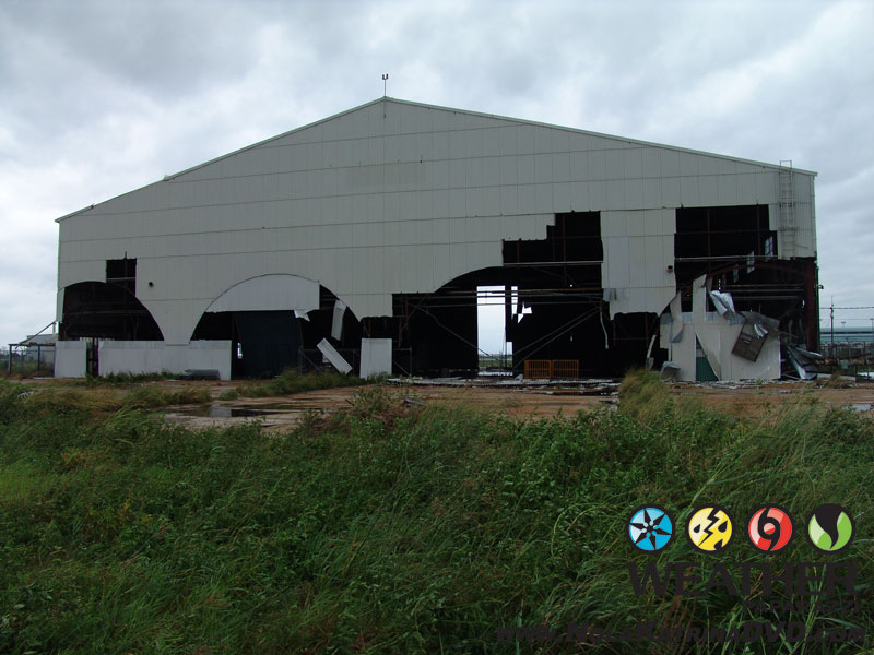
Damage to hangers at the New Orleans Airport after Hurricane Katrina 8/29/2005 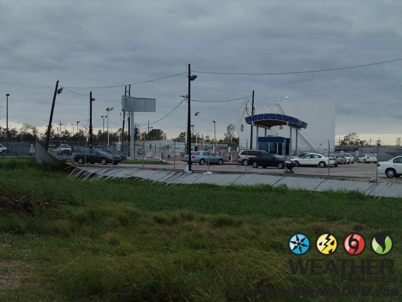
Damage around the New Orleans, LA airport after Hurricane Katrina 8/29/2005 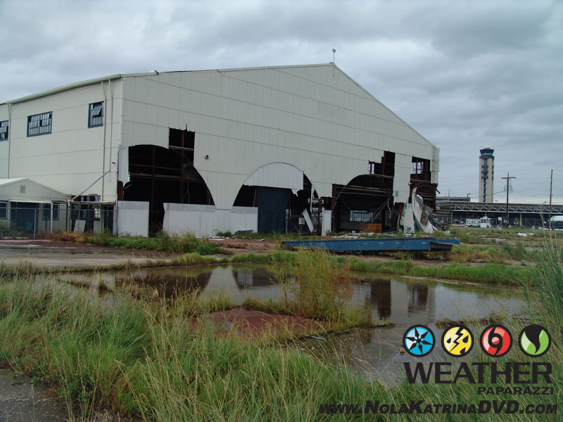
Damage to hangers at the New Orleans Airport after Hurricane Katrina 8/29/2005 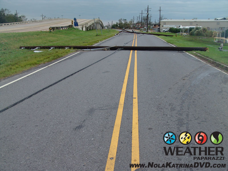
Damage around the New Orleans, LA airport after Hurricane Katrina 8/29/2005 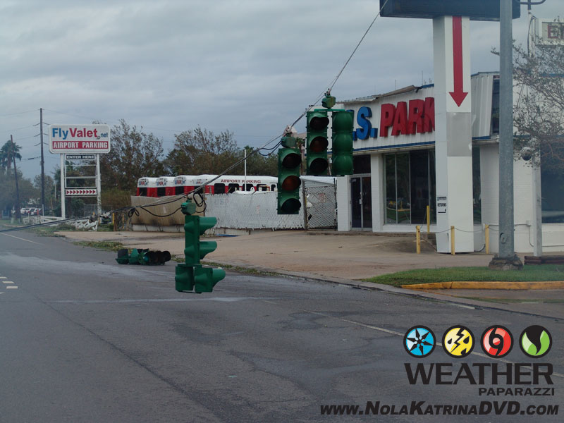
Damage around the New Orleans, LA airport after Hurricane Katrina 8/29/2005 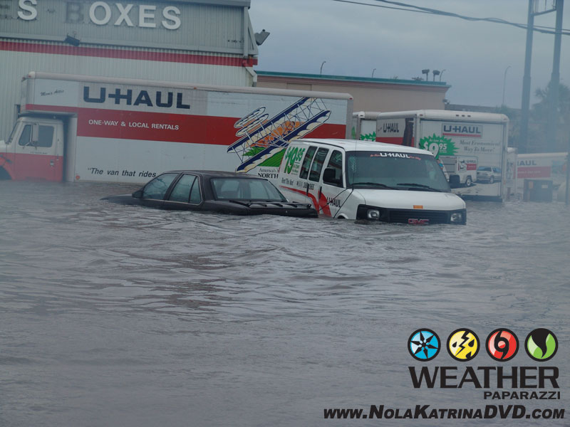
Flooding around Kenner, LA after Hurricane Katrina 8/29/2005
Now after being up for almost two days at this point, I had to do some phone interviews for the station back in Minneapolis, MN and then it was off to bed for me to get some much needed sleep.
The center of what was left of Hurricane Katrina was now well inland into Mississippi and the winds were weakening. Katrina was falling apart and on her way to being downgraded to tropical storm status.
August 30th, 2005 the first day in New Orleans, LA post Katrina.
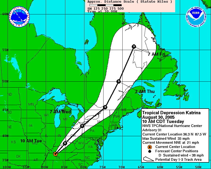
I had slept in until 10:00 a.m. and woke up to find that what was left of Katrina was now a tropical depression that was all the way up north into Kentucky. The National Hurricane Center had issued its final advisory on Katrina.
By the time I got out of the hotel to document the aftermath, it was already noon. I needed to pack up my gear and be ready to leave the hotel in case the owners of the hotel wanted to lock up the place and evacuate themselves out of the area.
I went back to Williams Blvd. and Veterans Blvd in Kenner, LA to document the people walking through the flooded roadway. Some where trying to get to the airport to be evacuated while others were checking out the damage and flooding.
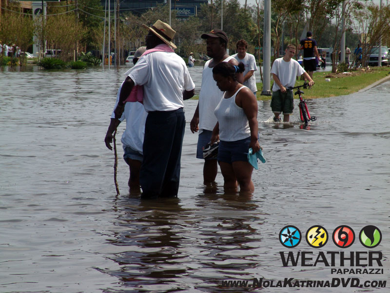
Flooding after Hurricane Katrina at Williams Blvd. and Veterans Blvd in Kenner, LA 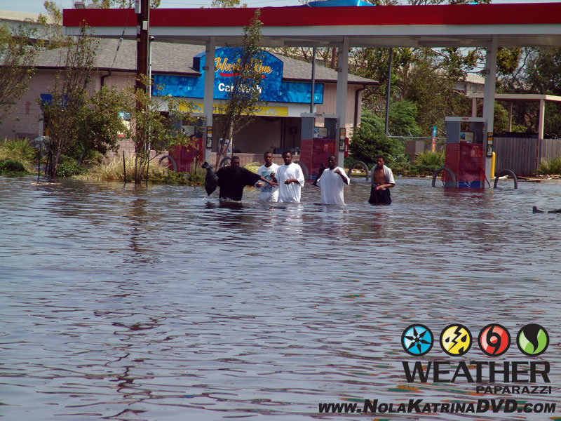
Flooding after Hurricane Katrina at Williams Blvd. and Veterans Blvd in Kenner, LA 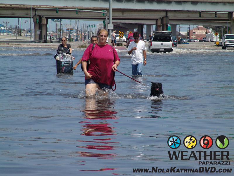
Flooding after Hurricane Katrina at Williams Blvd. and Veterans Blvd in Kenner, LA 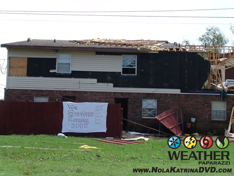
Damaged home in Kenner, LA from the winds of Hurricane Katrina 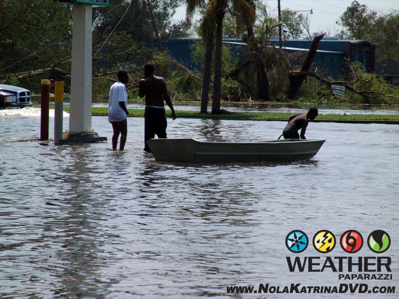
People walking with a boat in Kenner, LA after Hurricane Katrina.
I wanted to get back into downtown New Orleans to see what was happening as the reports I was hearing was it was underwater. I was only able to make it to the Orleans Parish line overlooking the 17th Street Canal and Pontchartrain Expressway pumping station pipes.
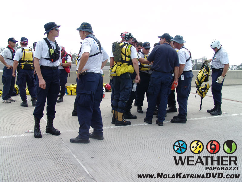
This is where the massive interstate 10 and 610 rescue effort was being setup. I was now focusing on shooting B-Roll video of rescue crews from as far away as Kentucky and Missouri along with the National Guard and FEMA were organizing the massive overwhelming tasking of trying to search and rescue people from the flooded out metro area.
B-Roll footage of people who were just rescued with their pets from the flooding around New Orleans, LA with interviews of people telling their story about how they were rescued.
Also includes shot of additional EMS personnel setting up, aerial shots from a bridge of cars underwater and air bubbling up to the surface.
Footage of the Pontchartrain Expressway pumping station surrounded by water with the New Orleans, LA skyline in the distance with a flooded out Interstate 10 in the foreground. Also footage of rescue boats bringing survivors to the staging area before being bused out of the area.
As the day went on, more people were being brought to this area of the interstate by the air boats but the FEMA rescue personnel.
It was just after 2:13 p.m. when I started filming this footage at Interstate 10 and 610 interchange which became a boat ramp rescue launching point for those needing to be rescued from the massive flooding that devastated the New Orleans, LA metro area.
It is interesting looking back at this footage and what I saw when I compare it to the other news reports that said their was no help for the people of New Orleans.
I was getting video which included Texas Task Force One rescue workers bringing people by boat to the staging area and B-Roll clips showing FEMA personnel setting up rescue operations and some of the first buses to come and take people out of the area.
I was interviewing rescue workers that came as far away as Kentucky to help out and they were on scene less than 24 hours after the storm ended.
I had a chance to help out with the camera by getting peoples stories and getting them on the air. I also collected phone numbers to call relatives of people I met to let them know they were still alive. It was amazing to also see all the people showing up with their personal boats to help out with the rescue. I think that if Katrina did not become a “Political” story and that if the local government officials stepped up and took action, the aftermath of Katrina would have been a much different story. There was a lot of people willing to help but it became a bureaucratic legal mess that added to the flooding.
Here are the photos I took of the rescue efforts on the interstate.
Task Force One personnel setup to enter the flood waters after Hurricane Katrina in New Orleans, LA 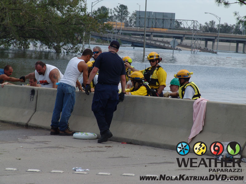
Task Force One bringing survivors to the staging area. 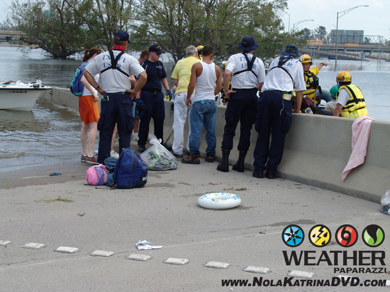
Task Force One bringing survivors to the staging area. 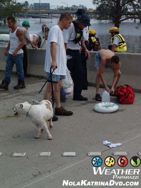
Task Force One bringing survivors to the staging area. 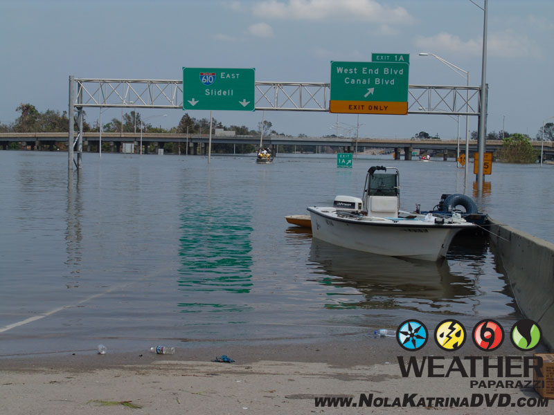
Interstate 10 and 610 interchange is now a boat ramp 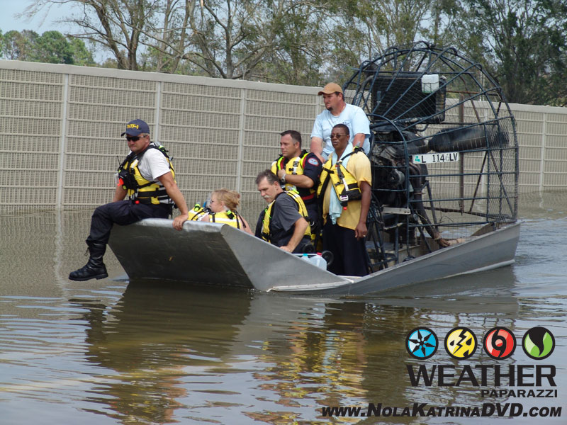
Task Force One bringing survivors to the staging area. 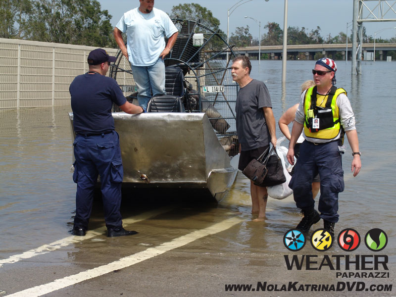
Task Force One bringing survivors to the staging area. 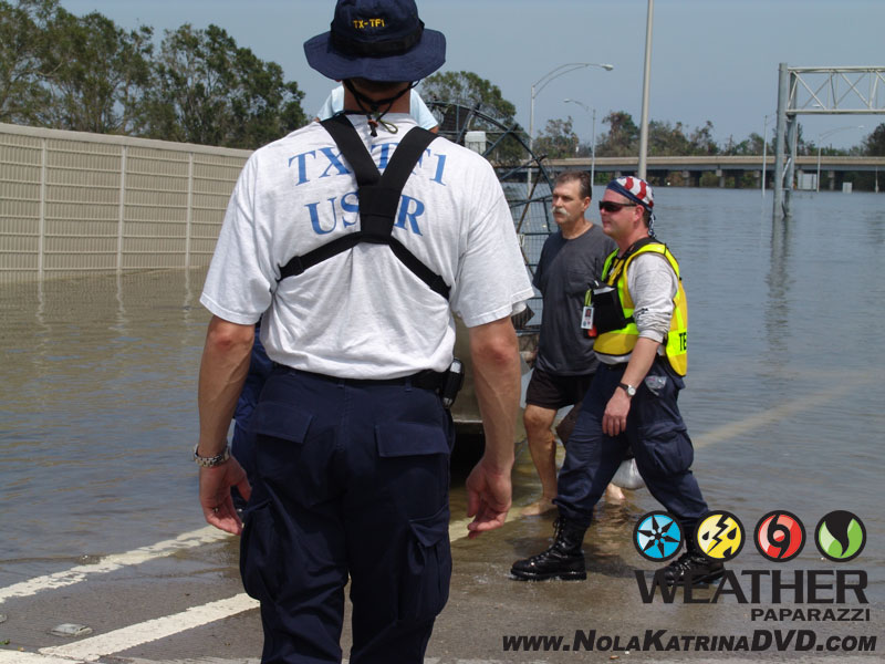
Task Force One bringing survivors to the staging area. 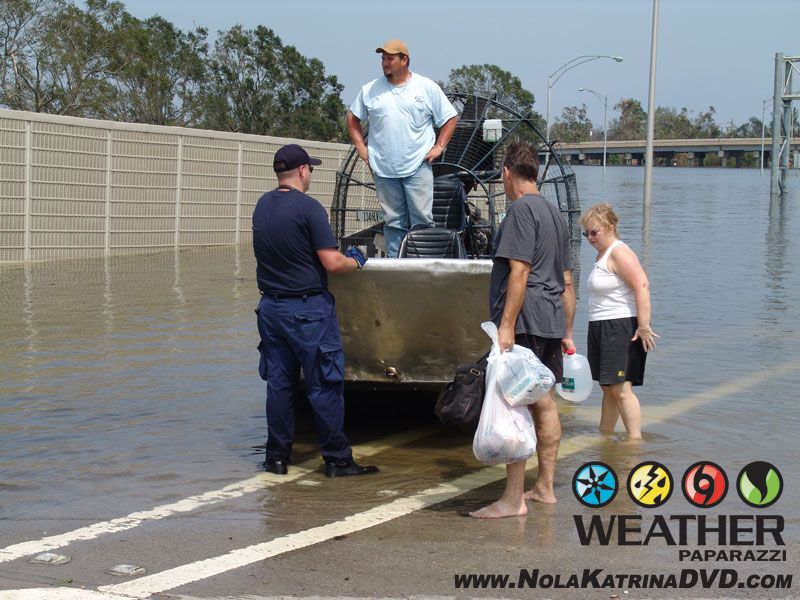
Task Force One bringing survivors to the staging area. 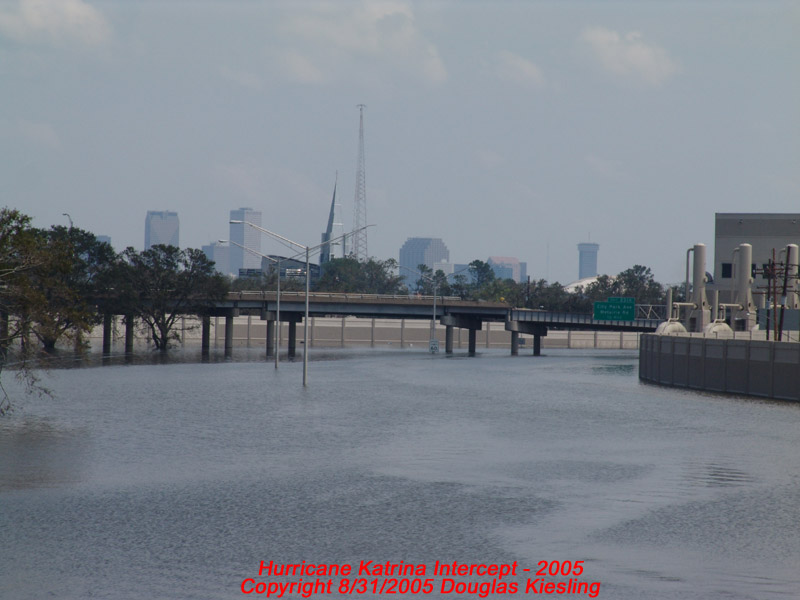
Submerged New Orleans, LA after Hurricane Katrina 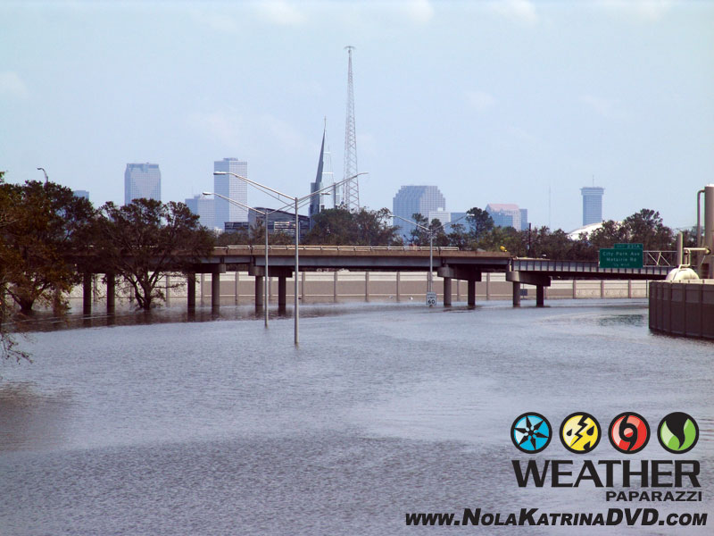
Submerged New Orleans, LA after Hurricane Katrina 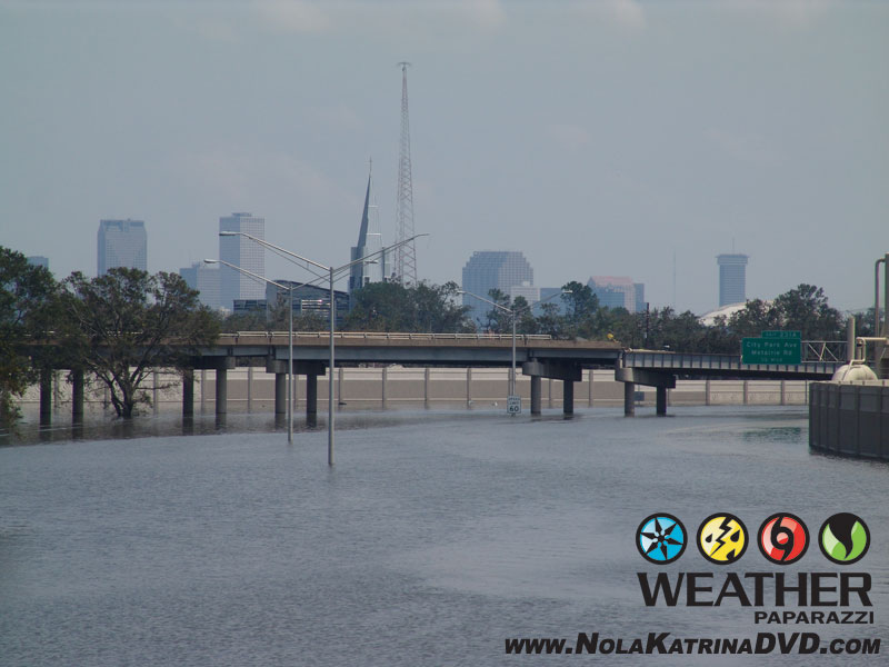
Submerged New Orleans, LA after Hurricane Katrina 
The Birth Of The Cajun Navy, local citizens come with their boats to help rescue residents. 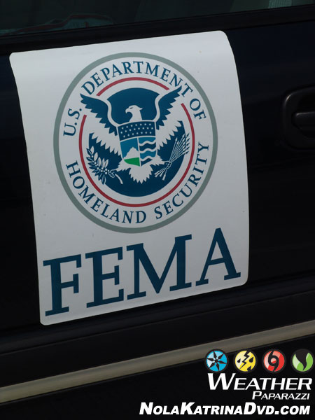
FEMA was there 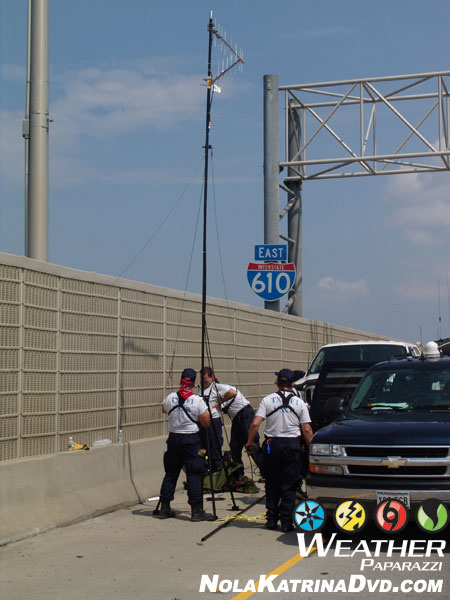
FEMA and Task Force One was on scene the next day but the city was flooded. 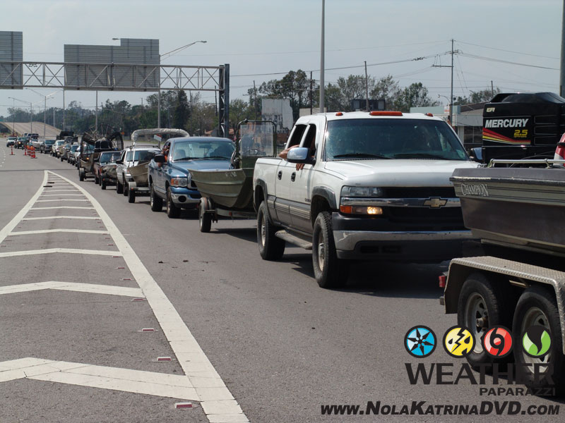
The birth of the Cajun Navy after Hurricane Katrina 
The birth of the Cajun Navy after Hurricane Katrina 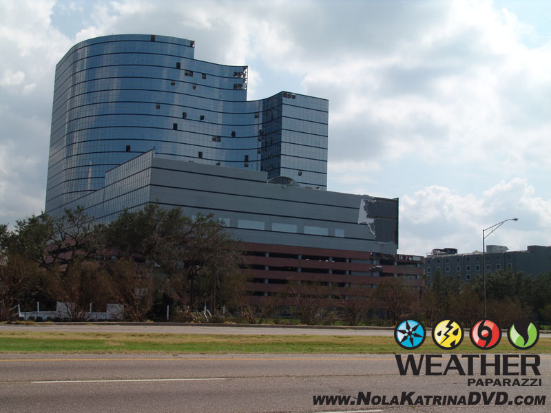
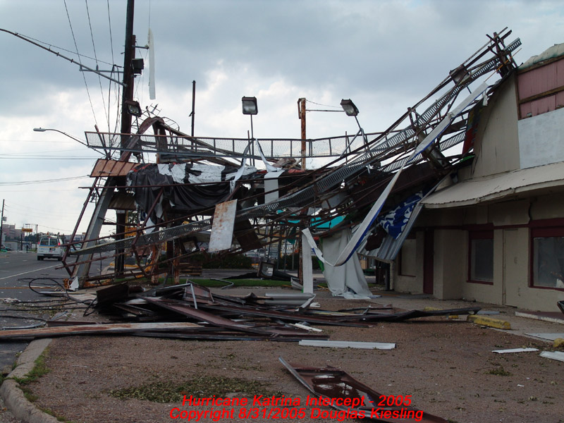
Office building with windows blown out after Hurricane Katrina. 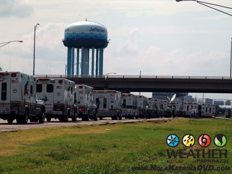
A fleet of Ambulances waiting in Kenner, LA after Hurricane Katrina 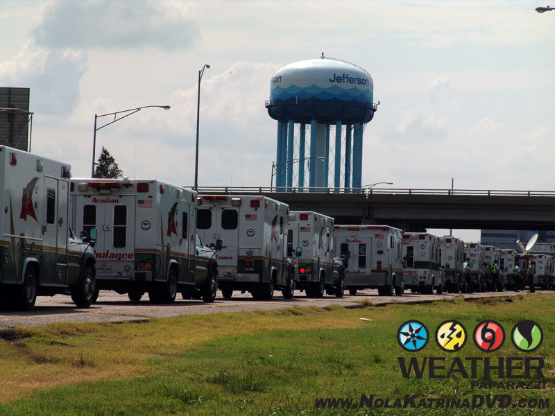
A fleet of Ambulances waiting in Kenner, LA after Hurricane Katrina 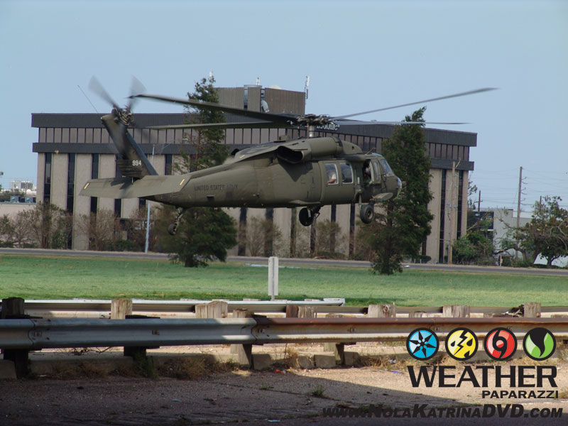
Army Helicopter dropping off survivors after Hurricane Katrina 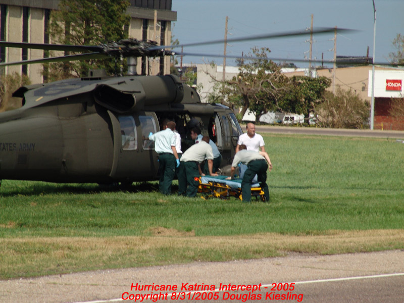
Army Helicopter dropping off survivors after Hurricane Katrina 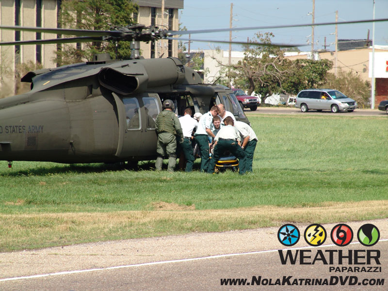
Army Helicopter dropping off survivors after Hurricane Katrina 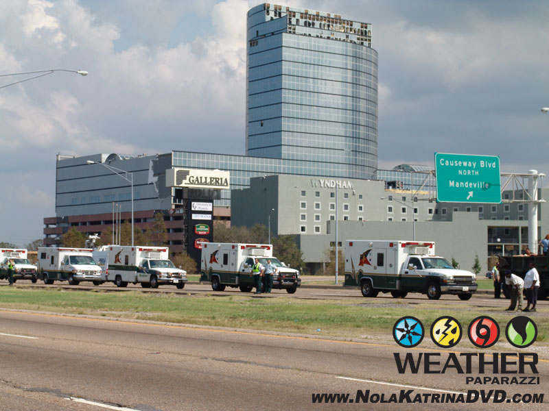
Fleet of rescue workers waiting to help out 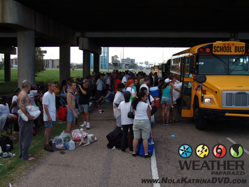
The fleet of buses waiting to take people away to shelters in Baton Rouge, LA and Houston, TX 
The fleet of buses waiting to take people away to shelters in Baton Rouge, LA and Houston, TX 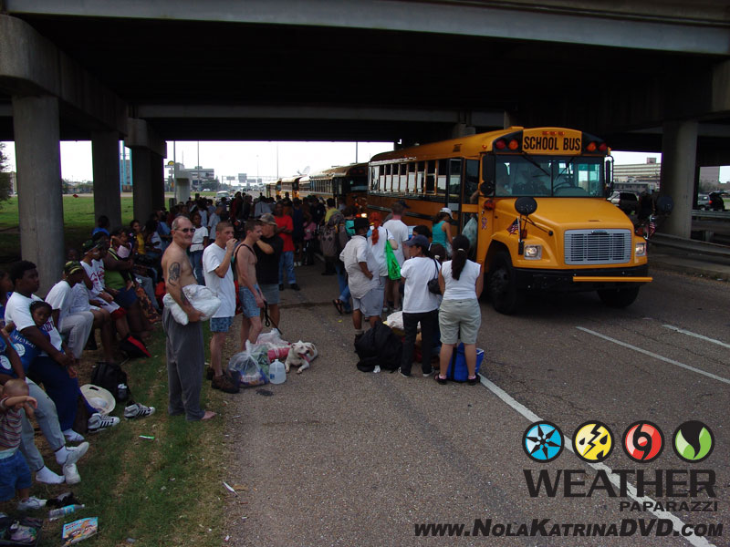
The fleet of buses waiting to take people away to shelters in Baton Rouge, LA and Houston, TX 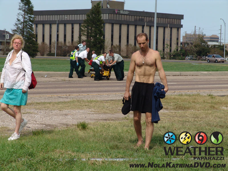
Survivors after being dropped off by a helicopter after Hurricane Katrina 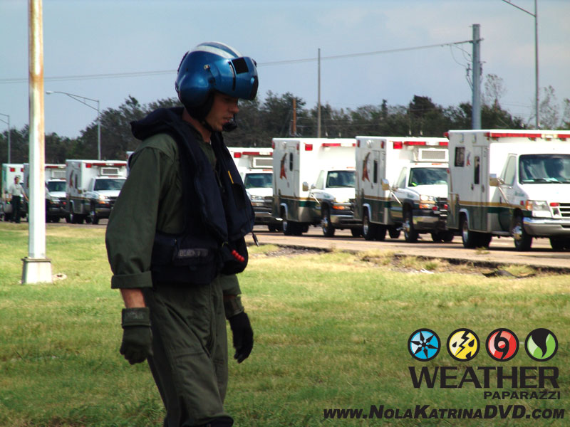
Helicopter crew member with the thousand yard stare 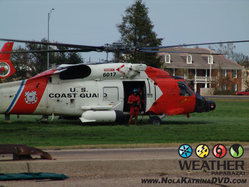
Coast Guard Helicopter dropping off survivors 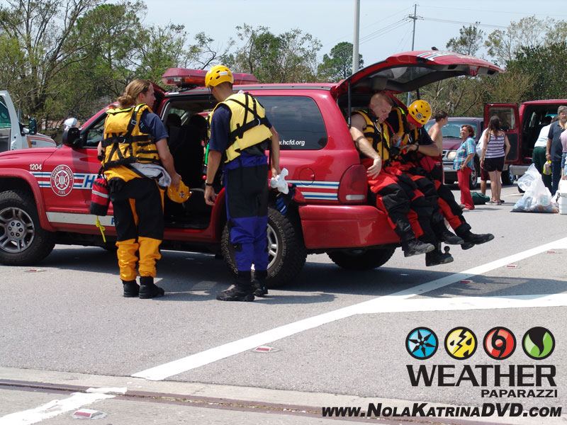
Rescue workers from several states around the county were already on scene waiting to help out. 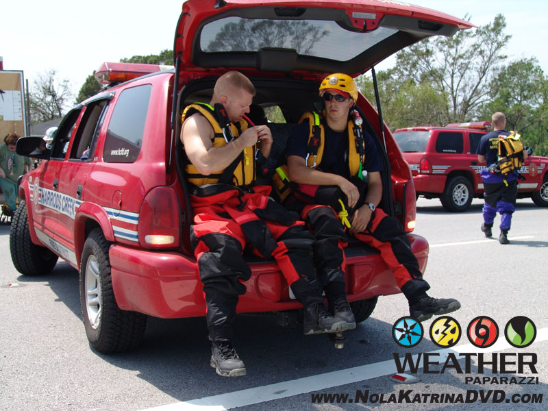
Rescue workers from several states around the county were already on scene waiting to help out. 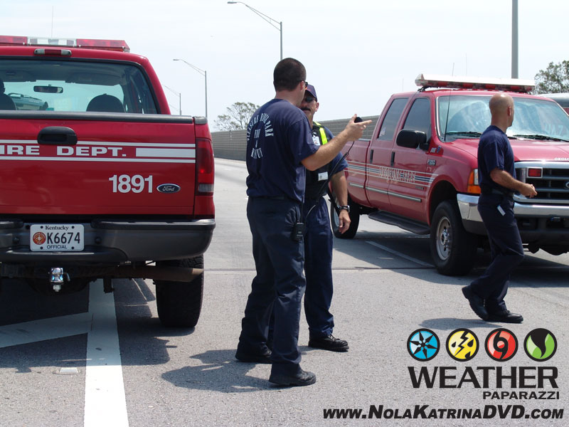
Rescue workers from several states around the county were already on scene waiting to help out. 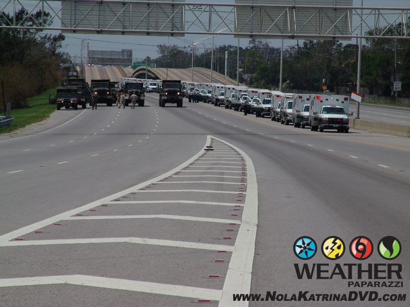
Fleet of Ambulances just waiting to help out 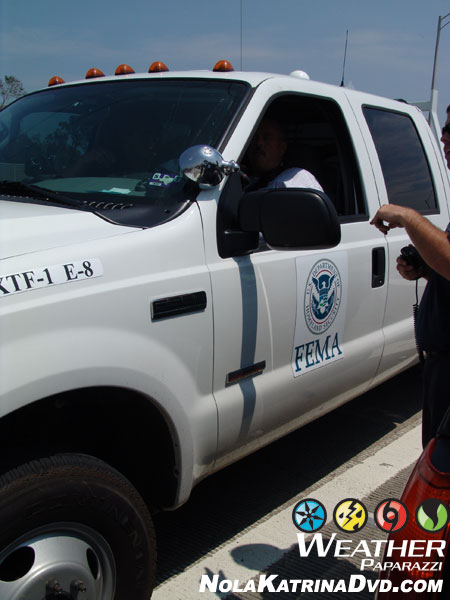
FEMA was on scene the next day. 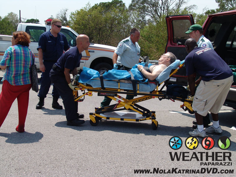
Crews taking away an injured person after the hurricane. 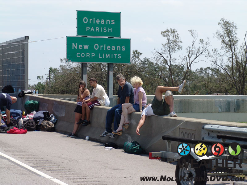
People waiting to go to a shelter after being dropped off by boat. 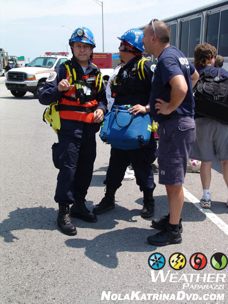
FEMA crews busy trying to organize the massive rescue but the flooding made it extremely difficult 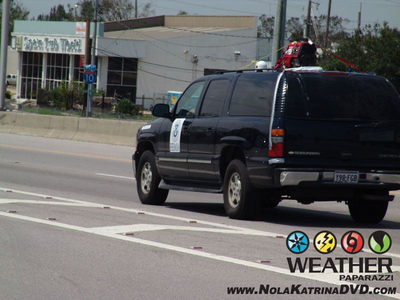
FEMA setting up communications 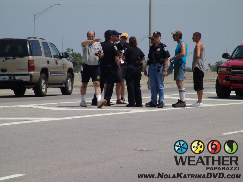
Rescue crews working on logistics. 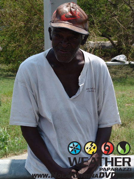
Another resident just waiting to see what happens next. 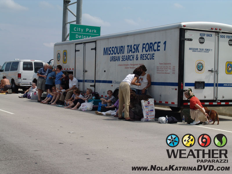
For those that did not think there was a response, this trailer came from Missouri to NOLA 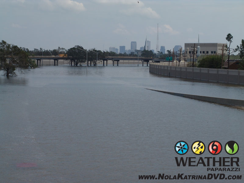
Flooded New Orleans, LA 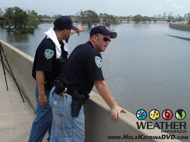
Rescue Crews stop to look at the size of the flooding. 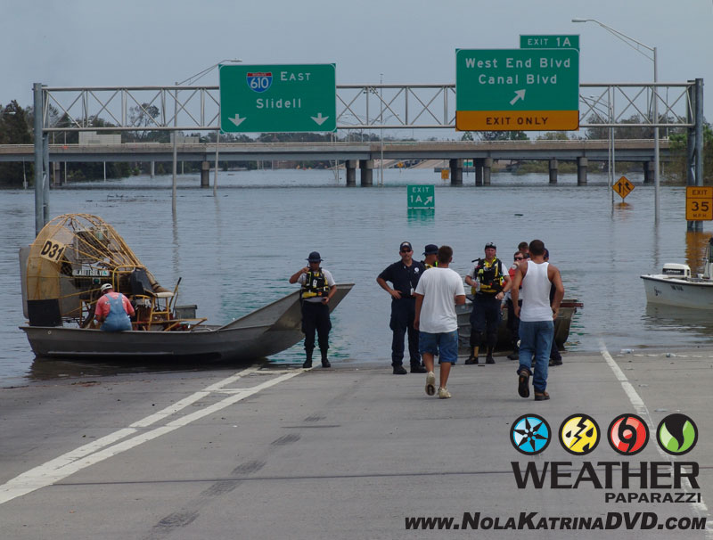
Rescue Crews using air boats on the interstate 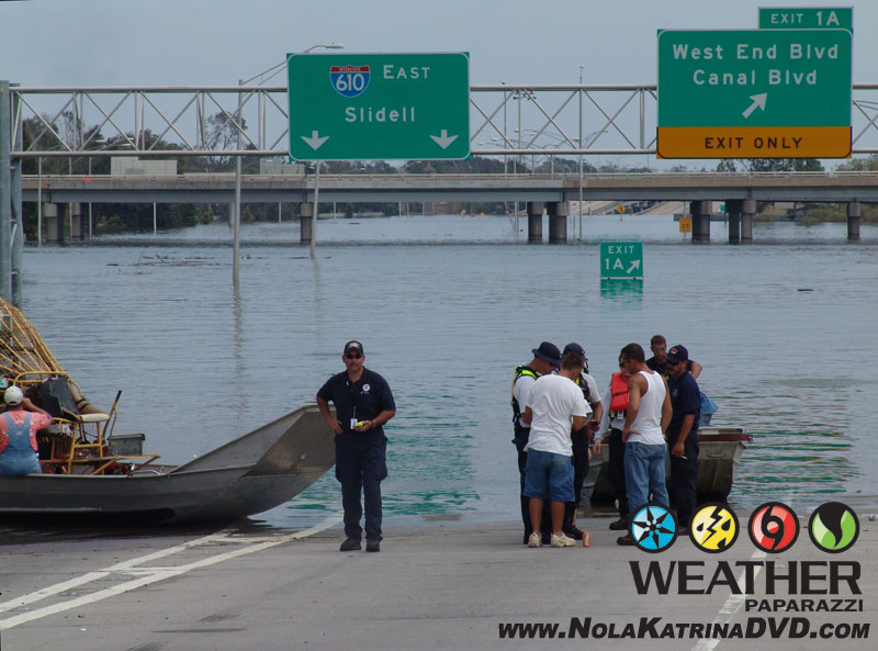
Rescue Crews using air boats on the interstate 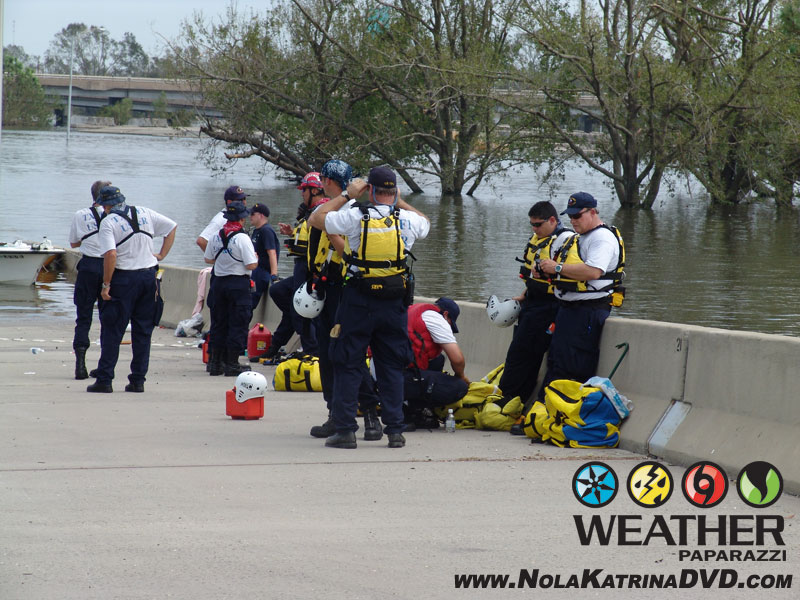
Rescue Crews getting ready to head back out into the flooding. 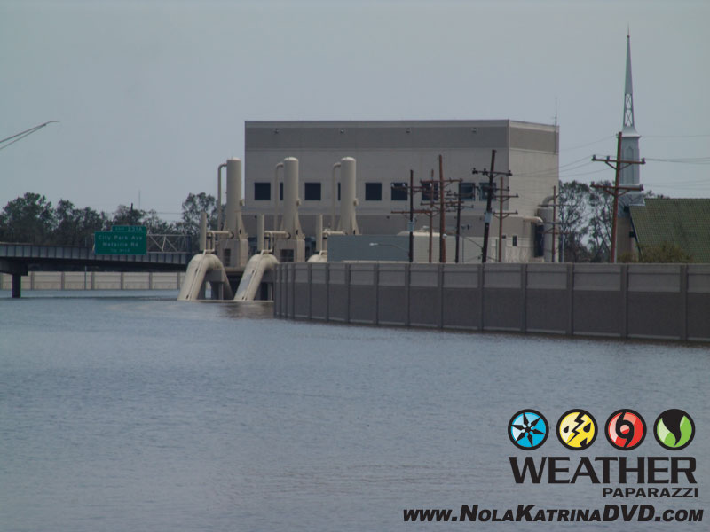
Submerged Pumping Station after Hurricane Katrina 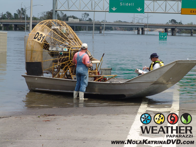
Air Boat docked on the interstate while waiting for fuel.
The last footage that I shot before leaving New Orleans was shot around 3:30 p.m. at Interstate 10 and Causeway Overpass.
The footage shows Coast Guard and National Guard helicopters landing and dropping off people who were rescued from their roof tops in New Orleans.
I witnessed the massive rescue effort that was happening as survivors were waiting for additional buses to transport them to shelters outside of the devastated area.
The rescue effort was massive but the one thing that the rescue crews were fighting was the flooding and the massive size of the area to search.
After documenting what I could before I left the scene, I met up with a man who was rescued with his dog.
He asked me for a ride to his moms house to check on the home and to take shelter in there in the city of Kenner, LA. I knew that the area was not flooded since it was right by my hotel.
I dropped him off and then asked him to tell me his story. The interview explains what happened to him which is pretty much the same story for most of the survivors of Hurricane Katrina in the New Orleans, LA area.
The last of the footage I shot was storm damage along Airline Highway just after 4:00 p.m.
Here is some images from the southeast side of the area of the airport before I went back to the hotel. Just wind damage. More bent over bill boards.
Wind Damage in Kenner, LA after Hurricane Katrina 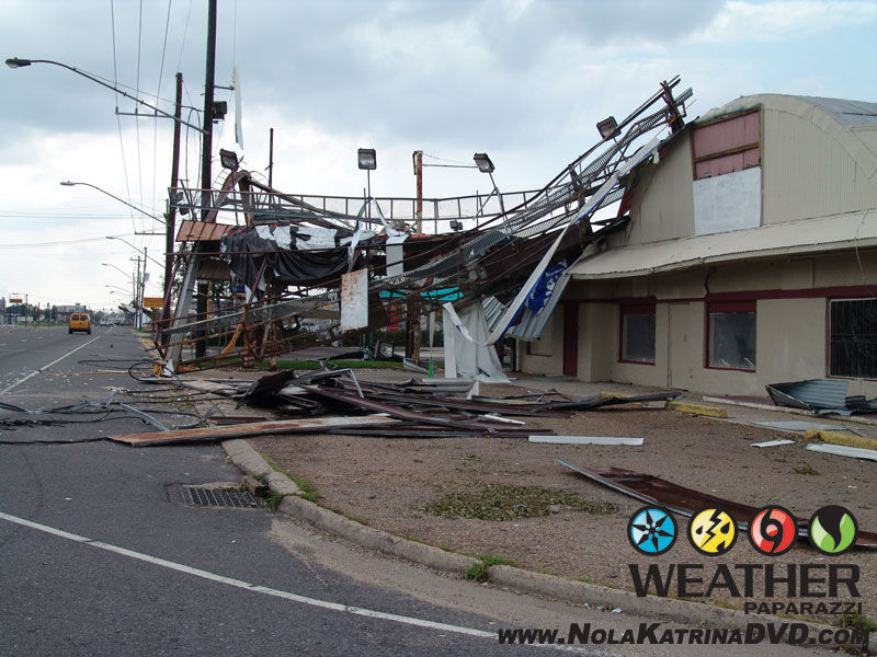
Wind Damage in Kenner, LA after Hurricane Katrina 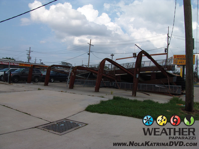
Wind Damage in Kenner, LA after Hurricane Katrina
After I shot my last photo and video of the aftermath, I drove back to the hotel I was staying at and the owners of the hotel were evacuating the area and heading west. They told me to make sure I lock up when I took off because they were heading out now.
I hung around the hotel for a few hours while I edited and uploaded the final video package to the tv station back in Minnesota and to the Weather Channel. By this time the cell phone service was pretty much dead. The cell towers that were not destroyed by Katrina’s winds were dead due to the power failures. The only way for me to make any phone calls was on the hotels land lines.
So I was pretty shocked when I was taking a break while the last of the video was uploading and I was outside and I got a phone call from the airline. A very nice woman told me she was calling me from the airline and asked me if I was still in New Orleans and if I was in a safe place. I told her I was safe and still in the area and she informed me that due to the hurricane, they were unable to bring an flights into the area for at least a week or more and did not know how to get me back home at this time.
I started laughing and she seemed confused until I told her I was down here for the storm and was with the media. I told here I had an SUV with a full tank of gas and three full gas cans and I was leaving the area in a couple hours to drive to Houston, TX. I then asked if she could get me on the first flight out of Houston, TX in the morning and back home to Minneapolis. She said “Mr. Kiesling you are the first person I have been able to contact in New Orleans that had a escape plan and I will make sure we get you on the first flight out of Houston, TX”
After waiting around for another hour to take care of the last of the video feeds, I was on the road to Houston, TX. Oh I did not have to lock up the hotel as the maintenance worker for the hotel stayed behind to watch over the place for the owners.
When I finally made it into Houston, TX, I did get a laugh out of the overnight rental car agent at the return desk. When I dropped off the truck, which by this time was on vapors and I did buy the fuel option, the funny part was the clerk looked at my paperwork and told me “I would have to pay for a one way rental fee since I did not pick the truck up from their location.” This was when I was about too lose it but kept my cool and told him “I would have loved to have been able to return this rental to the location that I picked it up from, but due to recent events that you may have heard about on the news, it is no longer on the face of the earth.”
He looked down at the paperwork again, looked up at me, looked back down at the paperwork again and said, “oh, wow I didn’t see that you just came from New Orleans, I’ll have the supervisor wave the fee.”
From the rental car return area it was a short trip over to the terminal to check in and wait for the counter to open up and check in for the 6:00 a.m. flight to Chicago and then to Minneapolis, MN.
I had been up for another 20 hours by the time I got on the flight and I was fried. I was seated in the very back of the plane where from the time I put my headphones on right after taking my seat, until after the plane landed in Chicago, I was out like a light. The flight from Chicago to Minneapolis was also another nice nap.
When I got to my truck that was parked in the airport parking ramp, I loaded the gear and then sat in the truck for a minute to reflect on what the hell just happened over the last five days. I had just witness the destruction of a major American city and didn’t have a clue as to how many people had died or what was going to happen in the next few days as the video I shot helped the story go world wide.
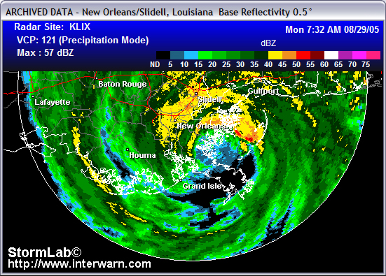
Here is the radar archive of Hurricane Katrina.