BRRRRRRRR, at sunrise this morning it was pretty freaking cold. The official report from the airport as -42F with outlying areas a few degree’s colder. I did find out the the Jeep temperature sensor bottoms out at -40F.
Now I’m heading home to get cleaned up then to head down to Minneapolis to see my Dad in the hospital.
Trying to keep my New Years Resolution about updating my personal blog and site as much as I do the Facebook and Twitter feed, here is the footage I just shot in northern Minnesota in the city of International Falls, MN. I’m on assignment up here after getting a request to come up here and document the cold temps.
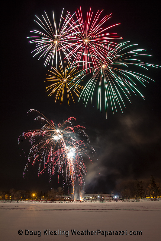
Happy New Year from downtown Saint Cloud, MN with fireworks over Lake George. 2013 was a great year in some ways but it also sucked big time in other ways. For 2014 I am not planning on working out and getting into shape, that was 2013’s plan and I can now say I can bench more then my body weight and squat twice my weight.
No, 2014 is about business. I have a lot of plans for the business in 2014 that were started in 2013 and are finally coming together. It is going to be an exciting year. Also my new years resolution is simple. Just update this site about as often as I update my Facebook Fan Page. Wow, I let this page go for about 2 months again. Time to start with the back dated updates.
Another video blog and another week back at the gym. Last night was another great aurora or Northern Lights event. We were just north of Saint Cloud, MN when the Auroras kicked in before midnight.
And now at the gym. I’m still hitting the gym and its showing some major results.
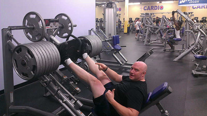
Lifting 1,000lbs
Here is a photo of me yesterday working out at the gym on a leg day. Yes, that is 1,000 pounds on the sled. No artificial enhancements for working out, just vitamins and protein, fueled with some haters and hard work. A few more months and I should have the last of the body fat off me.
Wow, yes I am really posting a blog and updating the site. I am just finishing up the chase in Wall, SD for the Winter Storm and Blizzard. Weather Channel is calling this Winter Storm Atlas and it is living up to it’s name as putting Winter Storm Season 2013-2014 on the map.
I did laugh my ass off at the hype over Tropical Storm Karen and the forecast computer models verified the weakening of the system. The real story was the storm system the caused the tornadic storms in Nebraska and Iowa yesterday and the major Blizzard that hit Wyoming and South Dakota.
This storm system has dumped an insane amount of moisture on the area in the last 48 hour’s with heavy wet snow but the upper Midwest need’s the moisture.
This morning I got up to a dark hotel room as the power was out. The power got knocked out late last night and it did not come back on until late this morning. The road’s are pretty much screwed until Sunday morning when South Dakota Department of Transportation workers told me that they plan on opening the roads after sunrise.
The area has insane huge snow drifts all over the place. Some of the drifts are over 15 feet high on the main roads.
Here is the footage I shot this morning. I tried to get out of the parking lot, nope, not happening.
Wall, SD major blizzard.
Just as fast as the wind was blowing, the storm moved on our of the area. The aftermath of the massive amount of snow is pretty impressive.
Wall, SD major blizzard and aftermath.
After the powerful blizzard moved out of the area, the cleanup of the massive snow drifts and impassible roads has begun.
Staff from the South Dakota, DOT said that Interstate 90 would not be
open until Sunday morning as the blowing and drifting has created a
nightmare situation throughout the region.
Footage shows the cleanup on the south side of Wall, South Dakota
after the winds died down. The roads are still impassible for the most
part as major snow drifts are blocking every roadway.
Check out the photo gallery for images from this chase.
A major blizzard has shut down half of the state of South Dakota on Friday as the powerful winter storm system the brought tornadoes to eastern Nebraska and western Iowa, brought several feet of snow to western South Dakota.
B-Roll footage starts out on Interstate 90 in the major whiteout conditions just outside of Wall, SD.
Heavy snow is still falling in Wall with wind gusts as high as 60 miles per hour.
Currently the area is without power as the powerful storm slams the region.
Wow, Facebook and Twitter updates are really getting in the way of updating my personal website. So while I kill time before taking Gustav to the vet today, I thought “Hey, maybe I should update my website”…
So what has been going on? Lot’s of stuff. I have been very busy with work and that is a good thing. Will try can get this site rebooted soon.
The Aurora Borealis brought autumn colors that filled the fall skies in central Minnesota tonight. The Northern Lights were spectacular with bright red, green, whites, purple and some orange color filling the sky.
The Auroras are from the latest geomagnetic storm that arrived earlier then expected and from the CME that burst from the sun a few days ago. At one point the Auroras were directly over head and even pointed into the southern sky.
Footage of the rapidly changing fall colors from Northern Minnesota around Lutsen, MN in the Sawtooth Mountain range along the north shore of Lake Superior.
Various footage of wide and very close up from on top of Moose Mountain and along the Temperance River valley.
Clip 1 Shot of the National Forest sign welcoming visitors to the Fall Color Tour in the Sawtooth Mountains.
Clip 2 Fall colors from on top of Moose Mountain
Clip 3 Pan shot on top of Moose Mountain
Clip 4 – 5 Fall colors along the Temperance River valley.
Clip 6 Driving along the Temperance River valley.
Clip 7 Traffic checking out the colors
Clip 8 – 9 Fall colors from on top of Moose Mountain
Clip 10 Tight shot with a fast pull back on top of the mountain.
Clip 11 Medium shot of lots of color
Clip 12 Tight shot of lots of color
Clip 13 – 18 Wide shot of lots of color
Clip 19 – 20 Medium shot of lots of color
Clip 21 – 25 Tight shots of colors
Clip 26 – 27 Wide shot of color and Lake Superior in the distance
Clip 28 Wide shot of colors from on top of the mountain
Clip 29 Medium shot of contrasting colors of Orange and Green showing the 50% color change.
Clip 30 – 31 Tight shots of color
Clip 32 POV driving shots under a canopy of color.
Thunderstorms with high winds and heavy rain impacted the the northern parts of the Twin Cities metro area this morning. Footage shot in the heart of downtown Minneapolis as the southern part of the line of storms moved through the metro area.
Clip 1 POV shot as while driving on Interstate 494 on the west side of town as the line of storms moved in.
Clip 2 Skyline shot of the city in the rain
Clip 3 Two women walking in heavy rain with an Umbrella
Clip 4 A couple walking in the rain along Nicollet Mall. Pull back and pan shot.
Clip 5 Women walking towards the camera with an umbrella
Clip 6 People walking in the rain on Nicollet Mall in downtown Minneapolis
Clip 7 Man walking with an umbrella
Clip 8 Two women in the rain waiting to cross the street under an Umbrella
Clip 9 People walking in the rain
Clip 10 Women on a bike waiting for the light to change in the rain
Clip 11 People in the rain with some farmers market booths
Clip 12 Farmers market merchant wearing garbage bags as a rain coat
Clip 13 – 15 Someone walking under an umbrella
Clip 16 Traffic in the rain
Clip 17 Someone walking in the rain under an umbrella