Just a quick post, it’s been a very busy week with the winter storm that hit the Saint Cloud, MN area. I have been out working in the weather almost every day. Check out www.StormChasingVideo.com for all the latest videos.
Also working on a site upgrade so I have not posted much since I have been busy behind he scenes.
As the season’s are changing and the temps are getting colder out. So this week, I finally did it. I asked Neva to marry me. I had some friend’s help out and I put together a cool little video for Neva to show her before asking her.
I know I have not blogged a lot in the last month but I have been extremely busy behind the scenes working on new stuff and traveling.
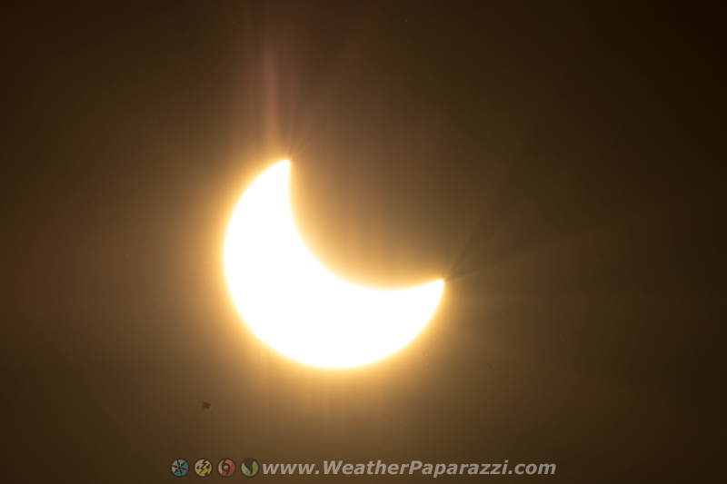
Today we had clear skies and at 5:30 local time tonight, Neva and I were able to go out and watch the eclipse. In the photo below, we were not the only ones watching it in the Saint Cloud, MN area because to the lower left, there is a Crane flying past the sun. Click on the image below to see the full size image.
Partial Solar Eclipse 10/23/2014 over central Minnesota
If you are taking a drive up north this weekend, check out the fall colors along Interstate 94 in Stearns County between Saint Cloud, MN and Avon, MN.
This is the weekend to get out and check out the fall colors that are
now at 50% to 75% peak with Saturday and Sunday looking to be the best
days to get out and view the show.
Footage shot around central Stearns County, MN near Avon, MN with various clips of the vivid fall foliage changing colors.
Clip 1 Static shot overlooking the fall colors.
Clip 2 Pan left shot of some vivid fall colors that pans to on old farm house.
Clip 3 Medium shot of vivid fall colors.
Clip 4 Tight up-close shot of vivid red Maple leafs
Clip 5 Tight panning shot of vivid red Maple leafs.
Clip 6 Static shot of various colors along Interstate 94
Clip 7 Static shot of traffic on Interstate 94 with vivid colors
Clip 8 Vivid yellows and reds.
Clip 9 Pan left of all the vivid colors over Achman Lake.
Clip 10 – 15 Static clips of the vivid colors over Achman Lake which is located along Interstate 94 just southeast of Avon, MN.
Clip 16 Wide shot of vivid fall colors.
Clip 17 Very wide shot of vivid fall colors.
Clip 18 – 20 Tight and medium shot of yellow Maple leafs.
Clip 21 POV left driving shot along an area of vivid colors.
I needed to get out of the office today and get back to doing some creative work. I saw that it was the first day of fall so what better excuse then to go out and document the fall colors just northwest of town.
9/22/2014 First Day Of Fall, Collegeville, MN Fall Colors
OK, no trips planned this week and spending the week working on getting a lot of stuff caught up. Lots of paperwork and receipts to go through, footage to edit, and working on the SCV “Singularity” project.
Lot’s of great stuff in the work’s in the next 6 week’s!
To say I have been busy this week is a little of an understatement. First I was covering the flash flooding from what was left of Odile in southeastern Arizona, then I thought going to the airport early was suppose to make it easier with security. On my way home while waiting at the gate for the flight to show up and go home, I ended up in the middle of a security lock down because the police were looking for murder suspects in Terminal 4. I was in Terminal 4…
9/18/2014 Phoenix, AZ Sky Harbor Locked Down, Behind Security Check Point
After a several hour delay, I was one of the lucky ones whose plane
was on the ground but parked and awaiting to be cleared to let the
passengers off the flight. A couple other planes were diverted and
flights canceled all because some idiot ran into the terminal to get
away from the police, a place where there are a lot of police.
Only after a couple day’s back at home, it was back on the road to chase again for the line of storm’s that were moving through western Minnesota. Below is the video that we shot yesterday near Willmar, MN. Nice seeing fall colors with falling hail.
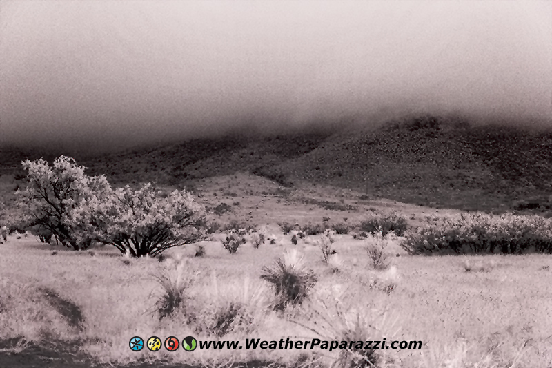
Just doing a recap the chase trip of what was the remains Hurricane Odile that moved into southeastern Arizona this afternoon and caused flooding in several communities. Knowing the area after chasing down here a few times now and learning the data holes, I was able to pull a rabbit out of the hat and actually get to see the effects of the flooding.
I was also able to get some Infrared photography in at 5000 feet above sea level with the cloud deck right on top of me.
Here is the footage. The footage is from the town of Pima, AZ in the first part of the video from the start to 1;24;00. and the second part of the video from 1;24;00 to end is from around the area of Whetstone, AZ.
9/18/2014 Tropical Storm Odile Flash Flooding in Southeast Arizona.
Clip 1, Road sign warning of flooding in the town of Pima, AZ
Clip 2 Flooding and the road blocked off in the town of Pima, AZ where Ash Creek started to flood.
Clip 3 Flooding at Ash Creek in Pima, AZ
Clip 4 – 6 POV driving through heavy rain on Interstate Ten south of 191 south of Pima
Clip 7 POV shot showing the heavy rain and the green vegetation when everything should be brown and dead.
Clip 8 Clouds moving up and over a mountain south of Pima, AZ **************** Clip 9 Flash flooding in the town of Whetstone with water running over the road and a sign warning of the road flooded ahead.
Clip 10 An SUV tries to navigate though the flash flooding but finds the road is turned to mud. The SUV almost gets suck but was able to back out of the hazard.
Clip 11 Rushing waters over a roadway in Whetstone, AZ
Clip 12 Rushing waters over a roadway in Whetstone, AZ
Clip 13 Flash flooding over a road in Whetstone, AZ
Clip 14 Flash flooding going over a road and down into a drainage ditch.
Clip 15 Flash flooding
Clip 16 Flash flooding with a tighter shot of the water going into the drainage system
Clip 17 Car driving through the flooding
Clip 18 Water covering another road
Clip 19 Rushing water flash flooding flowing over a road
Clip 20 Just south of Whetstone, very low clouds roll over one of the hill sides or mountains.
Clip 21 Long clip of the clouds moving from east to west as they roll over the top of a mountain.
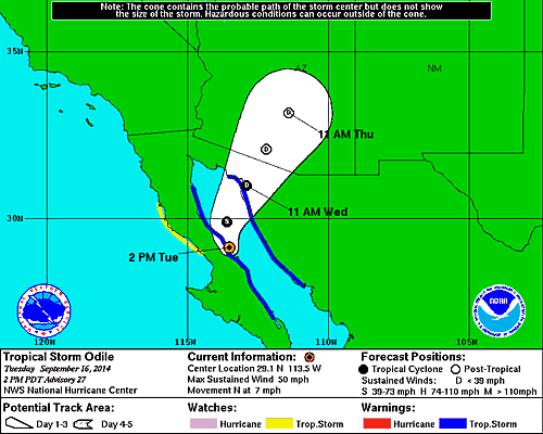
Yes, I headed back to Phoenix, AZ to cover what could be Tropical Storm Odile with the core of the storm making its US boarder crossing tomorrow.
National Hurricane Center graphic of Odile moving into Arizona
Based on the forecast models and experience chasing, this system look’s like it will have a major impact on the region and my main concern what the moisture from the Sea of Cortez and Gulf of California will have on it.
Wow, today was an insane with the record amount of flooding that hit
the Phoenix, AZ area. After checking out the area south of Phoenix with
Ben yesterday and watching some intense dust devils, the storms finally
moved into the Phoenix region and all I can say is wow, the forecast
was spot on and the rain fall was dramatic.
It started out in the early morning hours with several inches of rain being dumped on the Mesa, AZ area just east of Phoenix. In no time at all, the flooding shut down several main highways.
9/8/2014 Phoenix / Tempe, AZ Flash Flooding B-roll
At sunrise, while the rest of the local media was all focused on
flooding on the west side of town, on the east side in the Mesa and
Gilbert areas on 60, I was pretty much one of the only videographers
around and only chaser on the ground.
In this video, Highway 60 and the park say it all. The roads were pretty much a lost cause until the water could be pumped out and in the park, check out the girl on the Kayak next to the basketball courts.
9/8/2014 Mesa, AZ Major Flash Flooding B-Roll
I was also checking out the area just west of the park where the neighborhood started to flood out. In just a few hour’s, the flooding from the highways and interstates being pumped out into the spill ways to drain off started to overflow according to the local residents and the water drained into their streets and homes.
9/8/2014 Mesa, AZ Extreme Flash Flooding Footage.
All I can say is wow, the forecast verified, the footage is incredible and from a chasing perspective, catching the 100 year storm in the Phoenix area was just amazing.