
Last night was interesting. I went to Iowa to storm chase and have some bugs to work out with the severe storm chasing with some new gear setups. Data, well the data was kind of an issue in Iowa but it has always been in issue along I35 in Iowa.
But my forecast area that I went over with Tony with the new computer model data he got his hands on and let me in on, it totally worked out. And people wondered what the BNVN secret was, it’s just better forecasting.
My target was for just south of Mason City around the Dow’s area around sunset.
Sure enough, this is what fired up.
BULLETIN – EAS ACTIVATION REQUESTED
TORNADO WARNING
NATIONAL WEATHER SERVICE DES MOINES IA
835 PM CDT THU APR 24 2008
THE NATIONAL WEATHER SERVICE IN DES MOINES HAS ISSUED A
* TORNADO WARNING FOR…
NORTHEASTERN HAMILTON COUNTY IN CENTRAL IOWA…
NORTHWESTERN HARDIN COUNTY IN CENTRAL IOWA…
SOUTHWESTERN FRANKLIN COUNTY IN NORTH CENTRAL IOWA…
SOUTHEASTERN WRIGHT COUNTY IN NORTH CENTRAL IOWA…
* UNTIL 915 PM CDT.
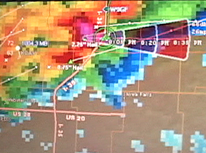
* AT 832 PM CDT…NATIONAL WEATHER SERVICE DOPPLER RADAR INDICATED A
SEVERE THUNDERSTORM CAPABLE OF PRODUCING A TORNADO 9 MILES
SOUTHWEST OF DOWS…OR 28 MILES EAST OF FORT DODGE…MOVING EAST AT
23 MPH.
* THE TORNADO WILL BE NEAR…
DOWS BY 850 PM CDT…
POPEJOY BY 900 PM CDT…
THIS TORNADO WARNING REPLACES THE SEVERE THUNDERSTORM WARNING THAT
WAS IN EFFECT FOR THE SAME AREA. GO TO A BASEMENT OR SMALL INTERIOR
ROOM ON THE LOWEST FLOOR!
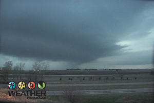
Sure enough, the forecast verified and I was sitting under this beast as it when the tornado warning was issued. I’m not sure since the visibility sucked but I think I got hit by some strong RFD winds that slammed my truck while I was watching what looked like a funnel back-lit by the lightning about a half mile or so away. But I can’t confirm it since this was a mega heavy rain beast, so as they say on the show Myth Busters, this was a “Plausible” tornado intercept since it was tornado chasing after dark. Plausible since I think I saw a funnel back lit and I got cored with hail, high winds and a ton of heavy rain at night when it’s the most dangerous time to chase.
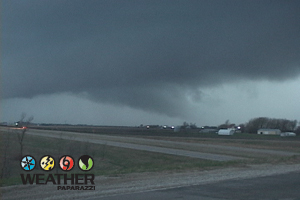
Here are some screen caps from this chase. The main problem with this chase was that it really was not that photogenic.
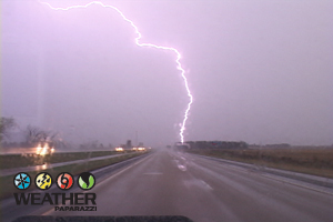
Here is a vid cap from the dash camera of the lightning. Most of the lightning I saw was in the clouds so you could not see much for cloud to ground blots. Also there is some lowering I saw on the way to the chase near Albert Lea MN. It looked cool for about a minute then it just looked like crap and I was back to my target area in Iowa.
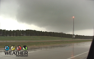
This was from the first wave of storms to hit the Dows Iowa area. This is a vid cap I did since I was spending most of my time looking around to make sure I was not going to die from Baseball sized hail that the radar was reporting. Below are more screen caps from the chase.
Ok, now it is time for me to get some sleep then wake up around noon and drive up to the US / Canada Boarder area to chase the winter storm. Looks like over a foot of snow up north and I want to be able to chase a tornado or tornadic warned storm one day and then a major winter storm the next. Nothing is more insane or intense then being able to get right into the mix of all of the different types of weather.