
That was fun. First major winter system to hit and the roads where not ready for it. Lots of crashes and slick roads around town.
Pre Halloween Live Stream
Don’t play with fire they said… Tomorrow might be boring as… or maybe a new chapter in video production and off season chasing.
Live from what is reported as the most haunted hotel in the upper midwest, The Palmer House, All Night Long!!! Of course I had to book the most haunted room in the place too. Live feed starts at 6pm and goes all night to 7am.
Back to Mexico Beach, FL one year later
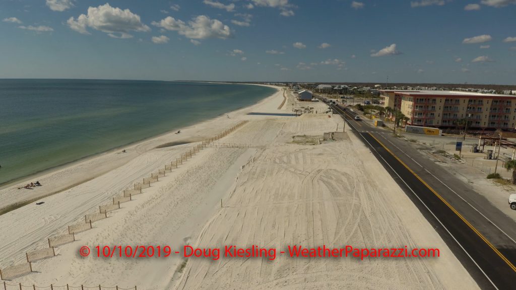
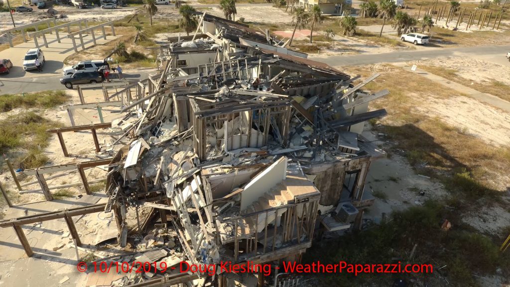
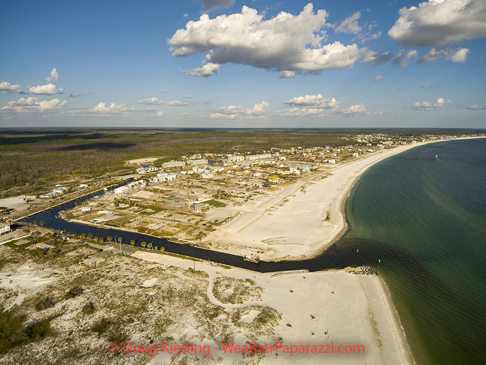
Today has been one of those days where it is a drive down nightmare lane, not memory lane… it is the one year anniversary of Category Five Hurricane Michael making landfall at Mexico Beach, FL in Bay County, FL.
I say nightmare because this was the scariest storm intercept of my life. Then again, I was in one of the worst possible position you could put yourself into without getting hit by the surge. The trip also was good to answer questions about time and distances for my own sanity since this was the first time being back at Mexico Beach, FL since the storm.
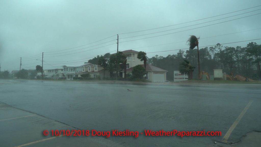
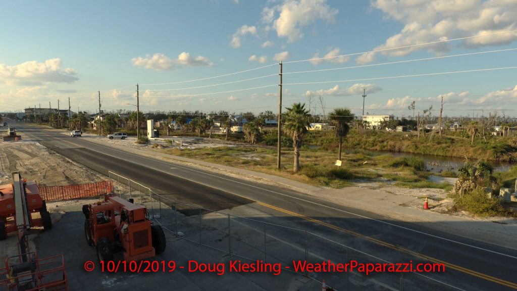
Below are some of the images from the area on the one year anniversary of the storm. You can see some of the damaged homes and structures are still waiting on insurance claims and a large amount of lots are empty where houses once stood.
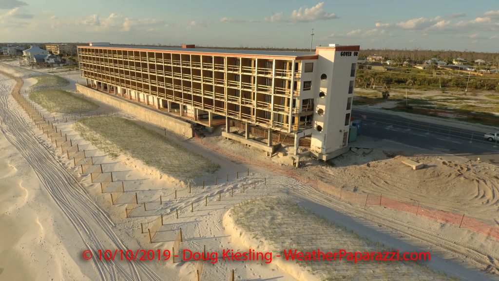
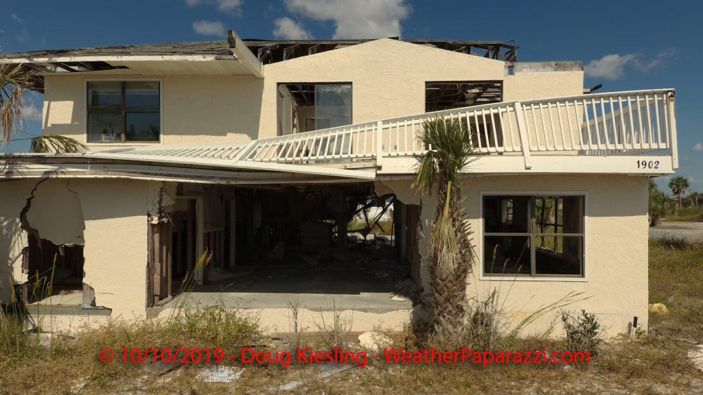
Over the next few weeks I’m working on a follow up documentary project for this storm and the recovery.
Getting back to the roots of chasing.
When I first started out chasing, it was not about getting the best video or video sales but it was about getting amazing still images. The other day I was able to get back to playing with the still images and time lapse work which will be a main focus for 2020 for me.
Here is the time lapse stuff I shot on 9/30 that was featured on The Weather Channel.
Starting later this year, major upgrades are finally taking place with the camera equipment and working on more in house productions as the state of media chasing has drastically changed over time.
Back in June we started chatting with a company that wanted to work with us on various different productions and after about four months of back and fourth, last week we are going ahead with it. This comes just in time for us to bow out of another project that sounded interesting at first but after careful consideration and looking at the pros and cons, we decided against it. The main reason was, do we work for someone else or do we become the production company and chart our own path and own future?
We picked the path that allowed us to chart our own path. From what I have heard through the chasing channels, us or “SCV” as a whole declining this project, has killed off this project. Probably for the best as this was a show that morphed into following around chasers chasing and talking about their chasing and into a competition show of one chasing team against another chasing team like so many of the other “So Called” reality shows. The last thing chasing needs is a show that makes all the chasers look like a bunch of jerk offs looking for destruction.
It was pretty funny as I was trying to be polite (rare eh?) and say we are not interested last week but Monday I was bugged about “Why Can’t You Do Both?” and “Can’t You Double Dip?” and this one made me laugh “You Will Have Lots Of Eyes On You” by one of the producers. The worst part about this whole project is that they wanted me to sign off on being locked into their “potential show” for up to nine (9) months without any pay. Yes, you read that correctly, nine months, no pay, can’t work on any other projects but yet my company works on lots of different projects every week with production companies all around the world.
The conversation ended with me saying the following.
Here is the fundamental problem. We already work in TV and everyone you have talked to has been on numerous reality clip shows, commercials or their own not so reality shows.
So eyes on means absolutely zero and it’s more of a pain in the ass vs being able to be incognito to get in and get out to get our shots.
The whole being on TV thing, we could be on the weather channel tomorrow if we wanted to with the footage we shoot today…
Seriously the show I did for in 2008, that only paid me scrap money and is still on the air 11 years later did nothing but brought me hate mail.
We could double or even triple dip but the problem is their is absolutely nothing in it for us but having a camera crew in our way all the time vs us being our own camera crew. Good luck with the project, but as of now, we’re not interested.
The following morning I followed up with a final message that just said.
And like I said, screen time, I opened The Weather Channel morning show this morning with this video
When I talked to everyone on my crew after I decided to not work on this project last week after hearing from another company that is looking to work with us, everyone was in agreement that a competition show would not be the best for chasing and doing more documentary project is the way to bring chasing into a much more friendlier public exposure after all the negative press over the last year by other’s.
And the marathon week is over
Ugh, the marathon of Hurricane Dorian is over. Last week was one of those weeks of should we or should be not, do I go or do I stay home and work the desk? In the end, I made the decision to stay home and work the desk while the team went out and covered the storm in the USA. We didn’t send anyone to the Bahamas since we I did not feel the need for footage and the risk involved of going to or sending anyone into a Cat Five hurricane in another country would be worth it.
In other news, I finally closed out the Smug Mug account. That account was basically a cool idea but waste of money. Over coming weeks, I will be reviewing and editing all of my photography to make sure only what needs to be in a gallery is in gallery and have everything organized correctly.
Auto incident in Saint Cloud, MN at 25th and 2nd Street
Footage of a wicked car crash that looked like it was a head on crash. While working in the home office, we heard a large boom that sounded like a tree limb hit the house but soon the police scanner revealed the sound was a wreck two blocks away.
Video is of the scene of a “Head On” Accident on west bound 2nd Street just west of the intersection of Division. Force of the wreck was great enough that two tow trucks had to try two times to pull them apart. Still working on details of what happened.
Behind The Chase – Lightning and camera tricks. – 8/18/2019
I did a new Behind The Chase (BTC) video for this week talking about the crazy lightning effects that happen on video from nearby strikes.
Video goes over the viral video from the Horry County, South Carolina Public Schools of one of their employees in a thunderstorm. https://twitter.com/EdPiotrowski/status/1162423232722591745
Baking Cookies by Bryan Snider https://www.bryansnider.com
Slow motion lightning by Matt Robinson http://metroscenes.com
September 2005 close lightning used in this video: https://youtu.be/2U_4XSaRTJY
Our August 2005 Lightning used in this video: https://youtu.be/VQrHwuXbpCc
Rove Dash Camera https://www.rovedashcam.com/products/rove-r2-4k-car-dashcam
Sartell, MN Flash Flooding Severe Storm – 8/13/2019
Pop up storms on my day off… Want to forecast weather, just look for days I don’t want to chase.
A severe thunderstorm hit the city of Sartell this afternoon and dumped heavy rain that rapidly flooded several roads and intersections.
At times the water on Pine Cone Road was over a foot deep at 2 1/2 Street.
Shot Description
Clip 1 Dark clouds moving into into the area.
Clip 2 Weak rotation and possible funnel cloud.
Clip 3 POV Driving in heavy rain.
Clip 4 POV Driving in heavy rain.
Clip 5 Cars driving through deep water on Pine Cone Road near the arena.
Clip 6 – 7 Sartell Police squad car block Pine Cone Road as heavy rain falls and flooding from the street ours into the ditch.
Clip 8 Tight shot of the water flowing from the road into the ditch.
Clip 9 Traffic on Pine Cone Road in the flooding.
Clip 10 Pickup truck driving through the flooding.
Clip 11-14 Several vehicles driving through the flooded road.
Clip 15 Police block part of Pine Cone Road from traffic driving into the flooding.
Clip 16 Water that is over 12 inches deep spinning around a storm drain.
Update for the last week.
So, no updates? What have I been up to for the last week since the chase in Iowa? Just working on paperwork here at the office and trying to get stuff caught up. Nothing exciting. Just working on the crews footage when they come in and entering data into Quickbooks.
Wow, so extreme… I’m joking since it is not extreme but boring. That is the other half of this fun life of chasing which is the not so fun side of paperwork.
Back home from the chase to Iowa.
Today was a different chase, was not that impressed with the setup but I was able to chase to I made the most of it.
Target this morning was the area around Blue Earth, MN to Mankato, MN. I left the house after lunch as the first cell of the day fired up and dropped large hail west of the Twin Cities metro and I was able to avoid that storm. I saw reports of hail up to four inches in size. No thank you, that would destroy my Jeep and I was focused on finding some rotation and maybe a lightning strike or two.
Just north of Medford, MN, I stopped to check the data since Minnesota is now Hands Free and I can’t use half of my equipment while chasing. Saw the data and the MD for a possible watch that I posted earlier today. I checked the weather data and yes, it was MOIST!
The problem with today was the upper level winds. The storms had some sheer and were rotating but they were not moving all that fast and pretty much sat in place as they grew and started raining and eventually rained themselves out and created outflow and new storms.
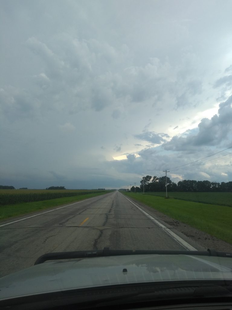
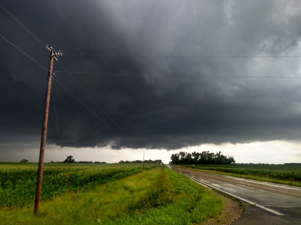
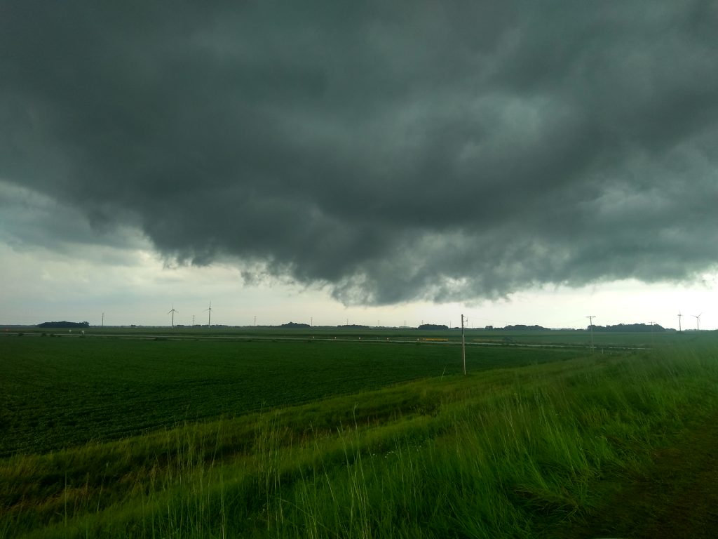
The first storm of the day near Owatonna, MN was trying but it was just not that impressive while the original target area did have a storm that was over 51,000 feet tall. So I headed southwest and intercepted the storm near Amboy, MN . Below is a photo of the storm as it was growing before it became outflow dominate.
When I got over to the base of this storm, it split but I followed this to Blue Earth, MN and into Iowa.
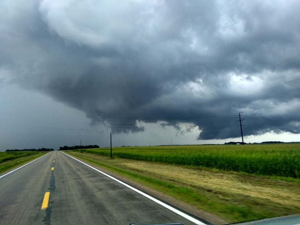
*** Update *** I was going to just edit the video later today (Tuesday) but I started reviewing the footage and I actually got a brief touch down when I continued to follow the storms into Winnebago County, Iowa and I was pretty much shocked that it showed up on the camera but I could not see it but then again I had so much going on at that time with three different cameras and watching out for the storm that was about to slam the area I was at.
Here is the video from Winnebago County, IA