
Yes the hurricane Ike intercept is still on hold. What? Why have I not booked a flight and filed a claim for my piece of the Hurricane Ike gold mine.
Well, simple, there is one small problem and that is that hurricane Ike is small and heading for an area south of Houston that is rural at best with no real access to the coast. The storm is still small and trying to reform and people are trying to compare it to Katrina. Also, no real safe place to intercept and it will probably be coming in at night. Not much to see with Hurricanes at night.
Well, let’s compare it to Katrina. In the image below we have the classic hurricane satellite photo on the left which is Hurricane Katrina from 2005 and now Hurricane Ike from today. Look at the size of Katrina based off the tip of the gulf coast of Mexico vs the size of Ike.
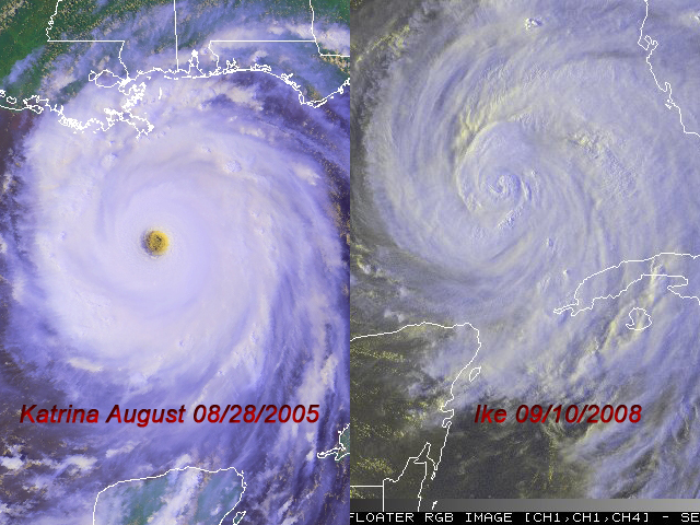
Now lets look at the fact that Katrina had a Monster sized well defined eye on her and Ike, well, it has something but it’s not very well defined. Katrina had the classic Buzz Saw look to her where as Ike, um not yet up to Katrina like form or strength.
Don’t get me wrong, I have several flight options and I’ll be out the door asap and on a flight if the storm looks better in the morning but right now it is not saying WOW to me.
The big question is, where is the eye? If you look at the Katrina image above and the Ike Image, where is Ike’s Eye?
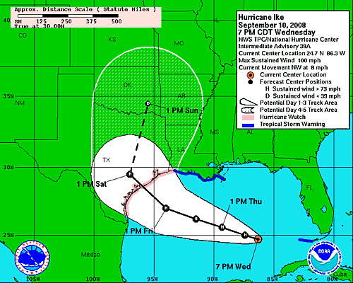
Now lets look at the forecasts. Yesterday the storm was forecasted to be making landfall around the Brownsville area along the USA and Mexico boarder. Now the latest GFDL forecast shows it could hit Houston. The forward speed of the storm has slowed down now to seven miles per hour from eight and the storm has not gone above 100 miles per hour. Below is the 7pm NHC forecast which shows the storm making a dreaded night landfall in the middle of pretty much rural areas of the Texas Coast.
And here is the 11pm forecast from NHC that show’s it is still 100 miles per hour and still moving in the same northwest direction but now there is a twist. The twist is that it could now get caught by the system coming out of the Midwest and turn to the north and hit southwest of Houston TX during the overnight hours on Friday and Saturday and that is a problem.
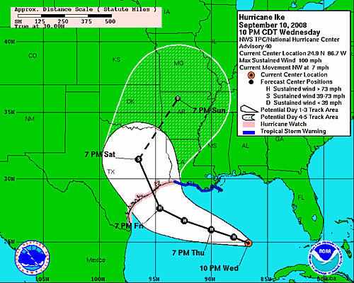
The problem is, will it make the last minute turn to the north between 7pm and 7am on Friday? Will Ike slow down more to make it a daytime landfall on Saturday and will Ike make it further north to hit along coast where you can’t get within 20 miles of the coastline with a tiny eye of a hurricane to try and intercept.
Too many thing’s telling me not to go because the number one factor is that if it hit’s at night, you won’t be able to see anything to shoot video of and that means I wont be able to get video of anything that is worth selling.
The trip is still up in the air so I may take off in the next 24 hours to chase Ike but too many things tell me to wait it out at home.
Plus, I have a ton of work to do here for clients so with my stringers going out their to chase the storm, BNVN will still have people out their to cover it, I just fear their may not be anything to cover. Time to get some sleep and see what is happening in the morning with Ike.