
Called off the Ike chase at the last minute yesterday and now I am pretty glad I did after looking at the latest data and IR Loop. Still no eye on the storm showing up on Sat and the center or what should be the eye still only about 10 miles across just gave me a bad feeling about chasing this storm.
Not a bad feeling like lot’s of bad stuff will happen but bad as in the storm looked as if it would never reach that major hurricane status that was forecasted to be just 24 hours ago (2am 09/11 cst).
One other thing to note after looking over all the models and reading all the different forecasts and just using my gut forecast, I have a feeling that the center of Ike will pass just to the east of Houston. That might spare the storm surge some what and put the worst of the storm on High Island during the overnight hours.
The main thing that really bugged me about the go or no go to chase Ike was the time of landfall which is going to be during the overnight hours and the fact that the winds never really got above 100mph after it got off of Cuba.
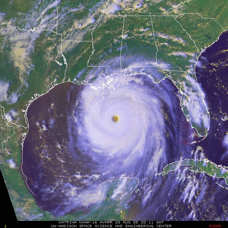
So for those that want to compare Ike vs Katrina, here are a couple Sat images with the storms in almost the same part of the Gulf the day before making landfall.
The first one is Hurricane Katrina the day before making landfall on August 28, 2005. The Max Sustained Winds with Katrina at this point were 165-175 Miles Per Hour (see 10am and 4pm nhc forecasts since someone will nit pick about facts I post… http://www.nhc.noaa.gov/archive/2005/KATRINA_graphics.shtml )
Now this one is from just before sunset tonight 9/11/2005 of Hurricane Ike.
Ike might be as big as Katrina, Ike might be kicking up some storm surge like all tropical systems do, but Ike is not and never will be like Katrina which was up to Super Insane (my term) Hurricane status of 175mph sustained winds the day before making landfall.
The day before Ike is to make land fall, I look at the Satellite image and want to rename the storm to “Hurricane Cinnabon”.
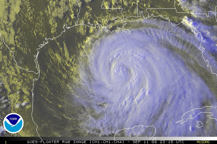
The wind field on this thing keeps reminding me of a Nor’Easter where the center of the storm is lame but the winds extend way the hell out from the center. Those who live east of the Galveston area should be concerned but not sure about the eye wall.